ไฟล์:China-Gansu.png
ไม่มีภาพที่มีรายละเอียดสูงกว่านี้
China-Gansu.png (268 × 218 พิกเซล, ขนาดไฟล์: 16 กิโลไบต์, ชนิดไมม์: image/png)
| รูปภาพหรือไฟล์เสียงนี้ ต้นฉบับอยู่ที่ คอมมอนส์ รายละเอียดด้านล่าง เป็นข้อความที่แสดงผลจาก ไฟล์ต้นฉบับในคอมมอนส์
|
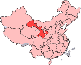
en: Location of Gansu Province in the People's Republic of China. See Locator maps of province-level divisions of the People's Republic of China for more information.
zh: 甘肅省在中華人民共和國的位置。另見Locator maps of province-level divisions of the People's Republic of China。

|
อนุญาตให้คัดลอก แจกจ่ายและ/หรือดัดแปรเอกสารนี้ภายใต้เงื่อนไขของสัญญาอนุญาตเอกสารเสรีของกนู รุ่น 1.2 หรือรุ่นใด ๆ นับจากนี้ที่ออกโดยมูลนิธิซอฟต์แวร์เสรี โดยไม่มีส่วนใดห้ามแก้ไข ไม่มีข้อความปกหน้าและปกหลัง สำเนาของสัญญาอนุญาตรวมอยู่ในส่วนชื่อ สัญญาอนุญาตเอกสารเสรีของกนู |
| ไฟล์นี้อยู่ภายใต้สัญญาอนุญาต ครีเอทีฟคอมมอนส์ แบบแสดงที่มา-อนุญาตแบบเดียวกัน 3.0 ต้นฉบับ | ||
| ||
| ป้ายแสดงสถานะลิขสิทธิ์นี้ถูกเพิ่มเพื่อให้เป็นไปตามการเปลี่ยนแปลงสัญญาอนุญาตของมูลนิธิวิกิมีเดีย จาก GFDL ไปยัง GFDL ควบคู่กับ CC-BY-SA 3.0 |

|
ภาพนี้มีภาพในรูปแบบเวกเตอร์ (SVG)
หากภาพ SVG ทำให้การแสดงผลดีกว่า หน้าที่ใช้ภาพนี้ควรเปลี่ยนไปใช้ภาพ SVG แทน File:China-Gansu.png → File:Map of PRC Gansu.svg
สำหรับข้อมูลเพิ่มเติมเกี่ยวกับภาพเวกเตอร์ ดูที่ การเปลี่ยนไปใช้ภาพ SVG ในคอมมอนส์ นอกจากนี้สามารถดูเพิ่มเติมเกี่ยวกับ ข้อมูลเกี่ยวกับการรองรับภาพ SVG สำหรับซอฟต์แวร์มีเดียวิกิ ได้ |
 |
ประวัติไฟล์
คลิกวันที่/เวลาเพื่อดูไฟล์ที่ปรากฏในขณะนั้น
| วันที่/เวลา | รูปย่อ | ขนาด | ผู้ใช้ | ความเห็น | |
|---|---|---|---|---|---|
| ปัจจุบัน | 21:56, 15 กรกฎาคม 2548 | | 268 × 218 (16 กิโลไบต์) | Schaengel89~commonswiki | transparent background |
| 05:39, 5 มิถุนายน 2548 |  | 268 × 218 (9 กิโลไบต์) | Ran | '''en''': Location of Gansu Province in the People's Republic of China. See Category:Locator maps of province-level divisions of the People's Republic of China for more information. '''zh''': 甘肅省在中華人民共和國的位置。另見[[:Cat |
หน้าที่มีภาพนี้
ไม่มีหน้าใดโยงมาที่ภาพนี้
การใช้ไฟล์ข้ามโครงการ
วิกิอื่นต่อไปนี้ใช้ไฟล์นี้:
- การใช้บน bn.wikipedia.org
- การใช้บน da.wikipedia.org
- การใช้บน de.wikipedia.org
- การใช้บน en.wikipedia.org
- Wikipedia:WikiProject Chinese provinces/Locator maps
- Xiahe County
- Yongjing County
- Daxia River
- Kongtong Mountains
- Subei Mongol Autonomous County
- Bairi Tibetan Autonomous County
- Zhuanglang County
- Huangyangchuan
- User:OldakQuill/temp
- Dunhuang Mogao International Airport
- Yongchang County
- Qingyang Airport
- Template:Gansu-geo-stub
- Xifeng, Qingyang
- Mazong Mountain
- Liancheng National Nature Reserve
- Longxi County
- Lintao County
- Min County
- Wushao Mountain
- 2008 Tibetan unrest
- Chongxin County
- Guanghe County
- Hezheng County
- Dongxiang Autonomous County
- Xihe County
- Wushan County, Gansu
- Qingshui County
- Qin'an County
- Gangu County
- Zhangjiachuan Hui Autonomous County
- Qinzhou, Tianshui
- Maiji, Tianshui
ดูการใช้ข้ามโครงการเพิ่มเติมของไฟล์นี้