ไฟล์:Bulgaria Simeon I (893-927).svg

ขนาดของตัวอย่าง PNG นี้ของไฟล์ SVG นี้: 627 × 599 พิกเซล ความละเอียดอื่น: 251 × 240 พิกเซล | 502 × 480 พิกเซล | 803 × 768 พิกเซล | 1,071 × 1,024 พิกเซล | 2,142 × 2,048 พิกเซล | 752 × 719 พิกเซล
ดูภาพที่มีความละเอียดสูงกว่า ((ไฟล์ SVG, 752 × 719 พิกเซล, ขนาดไฟล์: 232 กิโลไบต์))
| รูปภาพหรือไฟล์เสียงนี้ ต้นฉบับอยู่ที่ คอมมอนส์ รายละเอียดด้านล่าง เป็นข้อความที่แสดงผลจาก ไฟล์ต้นฉบับในคอมมอนส์
|
| คำอธิบาย | |
| วันที่ | created and uploaded 4 March 2007 |
| แหล่งที่มา | งานของตัว |
| ผู้สร้างสรรค์ | Todor Bozhinov |
| การอนุญาต (การใช้ไฟล์นี้ใหม่) |
ไฟล์นี้อยู่ภายใต้สัญญาอนุญาต ครีเอทีฟคอมมอนส์ แบบแสดงที่มา-อนุญาตแบบเดียวกัน 2.5 ทั่วไป
|
| เวอร์ชันอื่น |
[]
|
cs.png)
.png)
.svg)
_es.svg)
-hu.svg)
_pt.svg)
-zh.svg)
-ar.svg)
.svg)
Notes
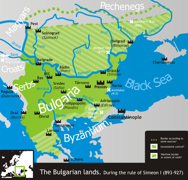
- 1 According to, among others, Crampton, Delev, Dobrev and Lalkov.
- 2 Bulgaria ruled all land east of the Danube and west of the Dnieper according to Constantine VII's De Administrando Imperio (c. 950), but actual Bulgarian control was often partial, weak and/or inconsistent in many of the scarcely-populated areas north of the Danube.
- 3 That is, unconfirmed by a peace treaty and only controlled during military campaigns in the Byzantine lands. These, however, comprised much if not most of Simeon's rule.
- The northern border is conjectural, as its exact location is practically unattested.
References
- Crampton, R.J. (พ.ศ. 2548) A Concise History of Bulgaria, Cambridge University Press, pp. p. 13 ISBN 0521850851
- Delev, Petǎr; Valeri Kacunov, Plamen Mitev, Evgenija Kalinova, Iskra Baeva, Bojan Dobrev (พ.ศ. 2549) "9 Bǎlgarskata dǎržava pri Car Simeon" in (bulgarian) Istorija i civilizacija za 11. klas, Trud, Sirma
- Dobrev, Hristo (พ.ศ. 2522) (bulgarian) Bǎlgarski voenen atlas, โซเฟีย: Voenno izdatelstvo, pp. pp. 152−153 OCLC 46136451
- Koledarov, Petǎr (พ.ศ. 2532) (bulgarian) Političeska geografija na srednovekovnata bǎlgarska dǎržava 2 (1186–1396), Bulgarian Academy of Sciences
- Lalkov, Milčo (พ.ศ. 2540) Rulers of Bulgaria, Kibea, pp. p. 24, p. 66 ISBN 954-474-098-8
| Annotations | This image is annotated: View the annotations at Commons |
.svg)
ประวัติไฟล์
คลิกวันที่/เวลาเพื่อดูไฟล์ที่ปรากฏในขณะนั้น
.svg&dir=prev)
.svg&offset=20070304205903)
.svg&offset=&limit=20)
.svg&offset=&limit=50)
.svg&offset=&limit=100)
.svg&offset=&limit=250)
.svg&offset=&limit=500)
| วันที่/เวลา | รูปย่อ | ขนาด | ผู้ใช้ | ความเห็น | |
|---|---|---|---|---|---|
| ปัจจุบัน | 21:50, 18 พฤศจิกายน 2562 | | 752 × 719 (232 กิโลไบต์) | Claude Zygiel | Side |
| 21:49, 18 พฤศจิกายน 2562 |  | 744 × 1,052 (520 กิโลไบต์) | Claude Zygiel | Details | |
| 03:38, 19 กุมภาพันธ์ 2554 |  | 752 × 719 (232 กิโลไบต์) | Ilmari Karonen | add missing xmlns attribute(s) | |
| 03:49, 8 มีนาคม 2550 | ไม่มีรูปย่อ | (232 กิโลไบต์) | Martyr | ||
| 16:13, 6 มีนาคม 2550 | ไม่มีรูปย่อ | (232 กิโลไบต์) | Martyr | ||
| 04:10, 6 มีนาคม 2550 | ไม่มีรูปย่อ | (230 กิโลไบต์) | Martyr | ||
| 03:03, 6 มีนาคม 2550 | ไม่มีรูปย่อ | (230 กิโลไบต์) | Martyr | larger names of battles, etc. | |
| 02:29, 6 มีนาคม 2550 | ไม่มีรูปย่อ | (232 กิโลไบต์) | Martyr | names of some important battles, etc. | |
| 17:22, 5 มีนาคม 2550 | ไม่มีรูปย่อ | (211 กิโลไบต์) | Martyr | river names, Thessaloniki name, rm line (northern border is conjectural), etc. | |
| 03:59, 5 มีนาคม 2550 | ไม่มีรูปย่อ | (194 กิโลไบต์) | Martyr | new |
หน้าที่มีภาพนี้
หน้าต่อไปนี้ โยงมาที่ภาพนี้:
การใช้ไฟล์ข้ามโครงการ
วิกิอื่นต่อไปนี้ใช้ไฟล์นี้:
- การใช้บน ar.wikipedia.org
- การใช้บน bn.wikipedia.org
- การใช้บน ckb.wikipedia.org
- การใช้บน da.wikipedia.org
- การใช้บน de.wikipedia.org
- การใช้บน el.wikipedia.org
- การใช้บน en.wikipedia.org
- การใช้บน eo.wikipedia.org
- การใช้บน es.wikipedia.org
- การใช้บน eu.wikipedia.org
- การใช้บน fa.wikipedia.org
- การใช้บน fr.wikipedia.org
- การใช้บน he.wikipedia.org
- การใช้บน hr.wikipedia.org
- การใช้บน hy.wikipedia.org
- การใช้บน it.wikipedia.org
- การใช้บน ja.wikipedia.org
- การใช้บน ka.wikipedia.org
- การใช้บน kk.wikipedia.org
- การใช้บน lt.wikipedia.org
- การใช้บน lv.wikipedia.org
- การใช้บน mk.wikipedia.org
- การใช้บน nds.wikipedia.org
- การใช้บน nl.wikipedia.org
- การใช้บน no.wikipedia.org
- การใช้บน oc.wikipedia.org
- การใช้บน pl.wikipedia.org
- การใช้บน pt.wikipedia.org
ดูการใช้ข้ามโครงการเพิ่มเติมของไฟล์นี้
.svg)
.svg)