ไฟล์:British Decolonisation in Africa.png
ขนาดของตัวอย่างนี้: 600 × 600 พิกเซล ความละเอียดอื่น: 240 × 240 พิกเซล | 480 × 480 พิกเซล | 768 × 768 พิกเซล | 1,024 × 1,024 พิกเซล | 2,000 × 2,000 พิกเซล
ดูภาพที่มีความละเอียดสูงกว่า (2,000 × 2,000 พิกเซล, ขนาดไฟล์: 406 กิโลไบต์, ชนิดไมม์: image/png)
| รูปภาพหรือไฟล์เสียงนี้ ต้นฉบับอยู่ที่ คอมมอนส์ รายละเอียดด้านล่าง เป็นข้อความที่แสดงผลจาก ไฟล์ต้นฉบับในคอมมอนส์
|
ความย่อ

|
ภาพแผนที่ทางประวัติศาสตร์นี้ ควรจะถูกสร้างใหม่เป็นกราฟิกส์เวกเตอร์ ซึ่งมีข้อดีอีกหลายประการ ดูเพิ่มเติมที่คอมมอนส์:สื่อต้องการเก็บกวาดสำหรับสารสนเทศเพิ่มเติม หากภาพนี้มีในรูปแบบกราฟิกส์เวกเตอร์อยู่แล้ว กรุณาอัปโหลดและแทนที่แม่แบบนี้ด้วย
{{vector version available|ชื่อภาพใหม่}}
แนะนำเป็นอย่างยิ่งให้ตั้งชื่อไฟล์เวกเตอร์ใหม่นั้นในรูปแบบ "British Decolonisation in Africa.svg" แล้วใส่แม่แบบ Vector version available (หรือ Vva) ซึ่งไม่ต้องใช้พารามิเตอร์ ชื่อภาพใหม่ |
| คำอธิบาย |
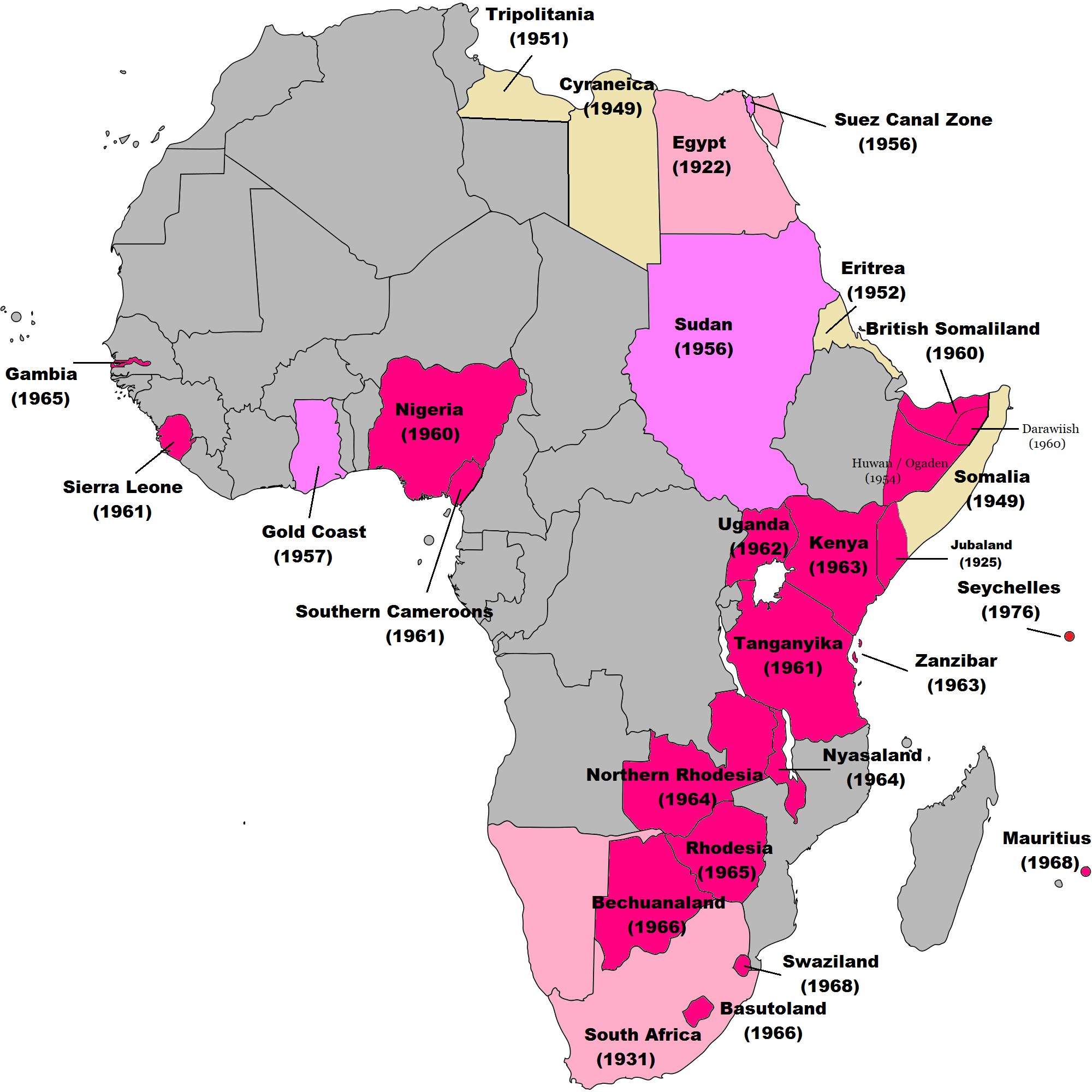
English: Map of British decolonisation in Africa. The beige areas were under British military administration after WW2. The different shades of pink refer to the stages of decolonization according to decades. |
| วันที่ | 1 พฤศจิกายน พ.ศ. 2551 (original upload date) |
| แหล่งที่มา |
Transferred from en.wikipedia; transfer was stated to be made by User:Hejsa. Blank map from File:BlankMap-World3.svg . Original text:
|
| ผู้สร้างสรรค์ | The Red Hat of Pat Ferrick t (log) |
| การอนุญาต (การใช้ไฟล์นี้ใหม่) |
Released into the public domain (by the author). |
การอนุญาตใช้สิทธิ
| |
งานนี้ได้ถูกเผยแพร่สู่สาธารณสมบัติโดยเจ้าของ The Red Hat of Pat Ferrick จากวิกิพีเดีย ซึ่งมีผลทั่วโลก ในกรณีที่กฎหมายไม่อนุญาตให้ทำเช่นนั้น: |
บันทึกการอัพโหลด
The original description page was here. All following user names refer to en.wikipedia.
- 2008-11-02 00:56 The Red Hat of Pat Ferrick 757×785× (171674 bytes) {{Information |Description=Map of British decolonisation in Africa. |Source=I created this work entirely by myself. |Date=1 November 2008 |Author=~~~ |other_versions= }}
ประวัติไฟล์
คลิกวันที่/เวลาเพื่อดูไฟล์ที่ปรากฏในขณะนั้น
| วันที่/เวลา | รูปย่อ | ขนาด | ผู้ใช้ | ความเห็น | |
|---|---|---|---|---|---|
| ปัจจุบัน | 15:49, 8 พฤศจิกายน 2564 | | 2,000 × 2,000 (406 กิโลไบต์) | Randomastwritter | ogaden |
| 10:23, 30 ตุลาคม 2564 |  | 2,000 × 2,000 (399 กิโลไบต์) | Randomastwritter | juba | |
| 08:38, 7 ธันวาคม 2556 |  | 2,000 × 2,000 (396 กิโลไบต์) | Zello | corrected map that better reflects historical realities (for example South-West Africa, Rhodesia), also Mauritius and Seychelle added, and new colour for territories under temporary military administration after WW2 | |
| 01:52, 23 พฤศจิกายน 2556 |  | 757 × 785 (159 กิโลไบต์) | Zello | Somalia became a UN Trust Territory under Italian administration in 1949. The correction was requested also on the talk page. | |
| 23:08, 13 กันยายน 2552 |  | 757 × 785 (168 กิโลไบต์) | Hejsa | {{Information |Description={{en|Map of British decolonisation in Africa.}} |Source=Transferred from [http://en.wikipedia.org en.wikipedia]; transfer was stated to be made by User:Hejsa. |Date=1 November 2008<br/> ({{Date|2008|11|02}} (original upload |
หน้าที่มีภาพนี้
หน้าต่อไปนี้ โยงมาที่ภาพนี้:
การใช้ไฟล์ข้ามโครงการ
วิกิอื่นต่อไปนี้ใช้ไฟล์นี้:
- การใช้บน ar.wikipedia.org
- การใช้บน ast.wikipedia.org
- การใช้บน azb.wikipedia.org
- การใช้บน az.wikipedia.org
- การใช้บน ba.wikipedia.org
- การใช้บน cs.wikipedia.org
- การใช้บน da.wikipedia.org
- การใช้บน de.wikipedia.org
- การใช้บน el.wikipedia.org
- การใช้บน en.wikipedia.org
- การใช้บน eu.wikipedia.org
- การใช้บน fr.wikipedia.org
- การใช้บน fr.wikiversity.org
- การใช้บน hy.wikipedia.org
- การใช้บน id.wikipedia.org
- การใช้บน it.wikipedia.org
- การใช้บน ka.wikipedia.org
- การใช้บน ko.wikipedia.org
- การใช้บน lv.wikipedia.org
- การใช้บน ms.wikipedia.org
- การใช้บน nl.wikipedia.org
- การใช้บน no.wikipedia.org
- การใช้บน pl.wikipedia.org
- การใช้บน pt.wikipedia.org
- การใช้บน ru.wikipedia.org
- การใช้บน tr.wikipedia.org
- การใช้บน uk.wikipedia.org
ดูการใช้ข้ามโครงการเพิ่มเติมของไฟล์นี้