ไฟล์:2016 Pacific typhoon season summary.png
ขนาดของตัวอย่างนี้: 800 × 600 พิกเซล ความละเอียดอื่น: 320 × 240 พิกเซล | 640 × 480 พิกเซล | 1,024 × 768 พิกเซล | 1,280 × 960 พิกเซล | 2,560 × 1,920 พิกเซล | 4,000 × 3,000 พิกเซล
ดูภาพที่มีความละเอียดสูงกว่า (4,000 × 3,000 พิกเซล, ขนาดไฟล์: 7.7 เมกะไบต์, ชนิดไมม์: image/png)
| รูปภาพหรือไฟล์เสียงนี้ ต้นฉบับอยู่ที่ คอมมอนส์ รายละเอียดด้านล่าง เป็นข้อความที่แสดงผลจาก ไฟล์ต้นฉบับในคอมมอนส์
|
ความย่อ
| คำอธิบาย |
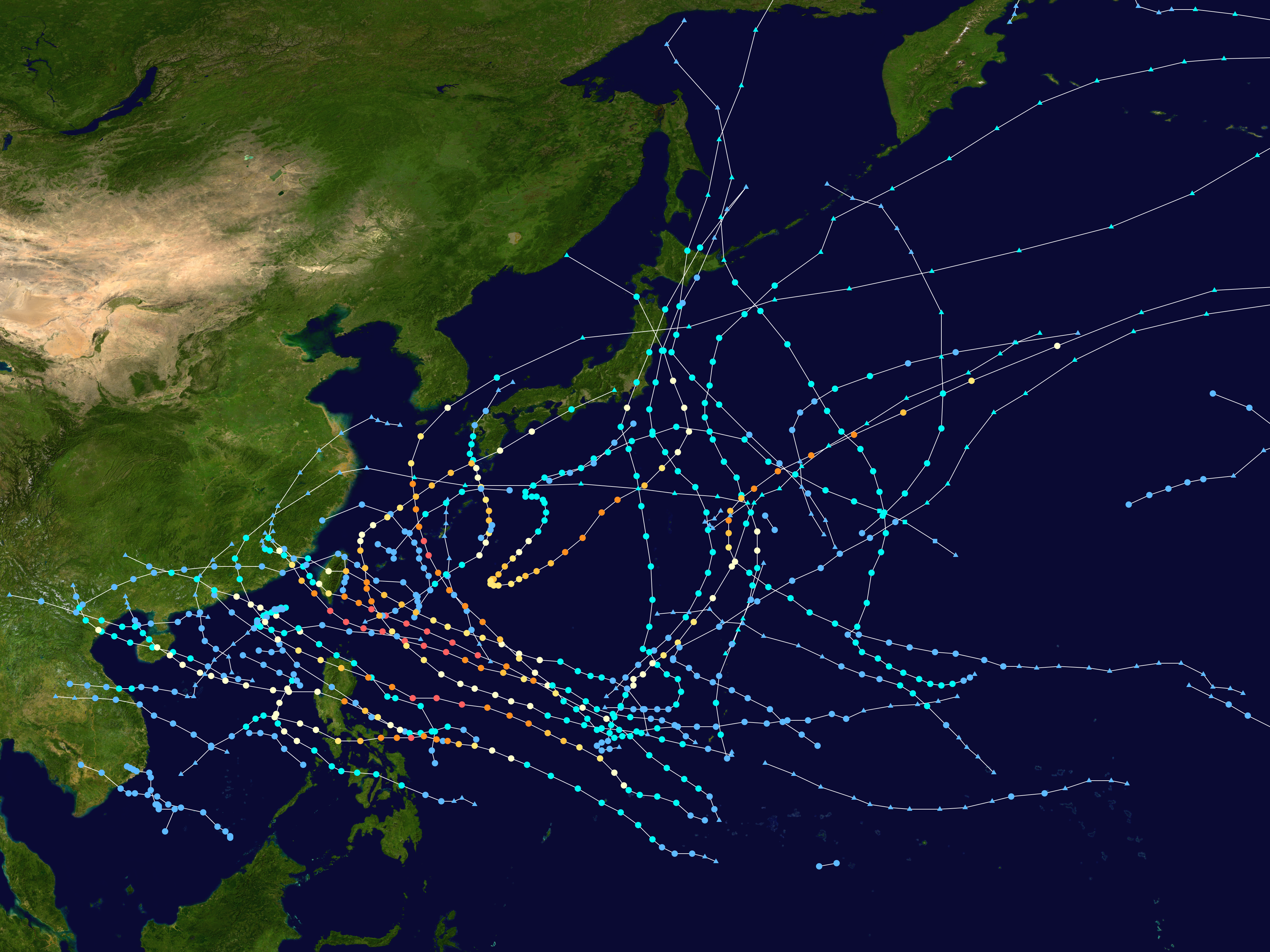
English: This map shows the tracks of all tropical cyclones in the 2016 Pacific typhoon season. The points show the location of each storm at 6-hour intervals. The colour represents the storm's maximum sustained wind speeds as classified in the Saffir-Simpson Hurricane Scale (see below), and the shape of the data points represent the type of the storm.
Tropical depression (≤38 mph, ≤62 km/h)
Tropical storm (39–73 mph, 63–118 km/h)
Category 1 (74–95 mph, 119–153 km/h)
Category 2 (96–110 mph, 154–177 km/h)
Category 3 (111–129 mph, 178–208 km/h)
Category 4 (130–156 mph, 209–251 km/h)
Category 5 (≥157 mph, ≥252 km/h)
Unknown
Storm type |
| แหล่งที่มา | Created using Wikipedia:WikiProject Tropical cyclones/Tracks. The background image is from NASA [1]. The tracking data is from the Joint Typhoon Warning Center's best track database |
| ผู้สร้างสรรค์ | Supportstorm |
| งานนี้ได้ถูกเผยแพร่สู่สาธารณสมบัติโดยเจ้าของ Supportstorm ซึ่งมีผลทั่วโลก ในบางประเทศ การกระทำดังกล่าวอาจไม่สามารถทำได้ตามกฎหมาย Supportstorm อนุญาตให้ทุกคนมีสิทธิ์ในการใช้ไฟล์นี้ในทุกเหตุผลการใช้ โดยไม่มีมีเงื่อนไข เว้นแต่กฎหมายไม่อนุญาตให้ทำเช่นนั้น |
ประวัติไฟล์
คลิกวันที่/เวลาเพื่อดูไฟล์ที่ปรากฏในขณะนั้น
| วันที่/เวลา | รูปย่อ | ขนาด | ผู้ใช้ | ความเห็น | |
|---|---|---|---|---|---|
| ปัจจุบัน | 09:50, 16 กุมภาพันธ์ 2563 | | 4,000 × 3,000 (7.7 เมกะไบต์) | Supportstorm | Primarily JTWC/JMA data |
| 12:29, 9 ธันวาคม 2561 |  | 4,000 × 3,400 (10.42 เมกะไบต์) | Supportstorm | Reverted to version as of 05:01, 16 March 2018 (UTC) | |
| 23:23, 30 สิงหาคม 2561 |  | 4,000 × 3,000 (9.98 เมกะไบต์) | David Petrovsky | Added also features known as the dimensions and size | |
| 12:01, 16 มีนาคม 2561 |  | 4,000 × 3,400 (10.42 เมกะไบต์) | Supportstorm | Best track update | |
| 13:45, 14 พฤษภาคม 2560 |  | 4,000 × 2,942 (8.26 เมกะไบต์) | Supportstorm | Reverted to version as of 21:26, 22 February 2017 (UTC) | |
| 10:22, 28 เมษายน 2560 |  | 4,000 × 3,375 (10.3 เมกะไบต์) | Morgan Siu | ||
| 04:26, 23 กุมภาพันธ์ 2560 |  | 4,000 × 2,942 (8.26 เมกะไบต์) | Supportstorm | Update (JMA weather map reanalysis up to October 31) | |
| 16:17, 23 ธันวาคม 2559 |  | 4,000 × 3,375 (10.3 เมกะไบต์) | Supportstorm | Update (JMA weather map reanalysis up to August 31) | |
| 20:43, 15 พฤศจิกายน 2559 |  | 4,000 × 3,375 (10.26 เมกะไบต์) | Supportstorm | Update | |
| 08:19, 30 ตุลาคม 2559 |  | 4,000 × 3,375 (10.14 เมกะไบต์) | Supportstorm | Update |
หน้าที่มีภาพนี้
หน้าต่อไปนี้ โยงมาที่ภาพนี้:
การใช้ไฟล์ข้ามโครงการ
วิกิอื่นต่อไปนี้ใช้ไฟล์นี้:
- การใช้บน bcl.wikipedia.org
- การใช้บน de.wikipedia.org
- การใช้บน en.wikipedia.org
- 2016 Pacific typhoon season
- Timeline of the 2016 Pacific typhoon season
- Template:2016 Pacific typhoon season buttons
- Typhoon Nepartak
- Tropical Storm Mirinae (2016)
- Tropical Storm Nida (2016)
- Tropical Storm Dianmu (2016)
- Typhoon Mindulle (2016)
- Typhoon Lionrock
- User:Nino Marakot/2016 Pacific typhoon season
- Typhoon Meranti
- Typhoon Malakas (2016)
- Tropical Storm Rai (2016)
- Typhoon Megi (2016)
- Typhoon Chaba (2016)
- Typhoon Songda (2016)
- Typhoon Sarika
- Typhoon Haima
- November 2016 Vietnam tropical depression
- Tropical Storm Aere (2016)
- User:Typhoon2013/PTS Format 1A
- Typhoon Nock-ten
- User:Tfmbty/2016 Pacific typhoon season
- Tropical cyclones in 2016
- User:HUYTK21
- การใช้บน es.wikipedia.org
- การใช้บน ja.wikipedia.org
- การใช้บน ko.wikipedia.org
- การใช้บน pt.wikipedia.org
- การใช้บน tl.wikipedia.org
- การใช้บน vi.wikipedia.org
- การใช้บน www.wikidata.org
- การใช้บน zh-yue.wikipedia.org
- การใช้บน zh.wikipedia.org
ดูการใช้ข้ามโครงการเพิ่มเติมของไฟล์นี้