ไฟล์:2010 Chile earthquake epicenter.png
ไม่มีภาพที่มีรายละเอียดสูงกว่านี้
2010_Chile_earthquake_epicenter.png (269 × 589 พิกเซล, ขนาดไฟล์: 112 กิโลไบต์, ชนิดไมม์: image/png)
| รูปภาพหรือไฟล์เสียงนี้ ต้นฉบับอยู่ที่ คอมมอนส์ รายละเอียดด้านล่าง เป็นข้อความที่แสดงผลจาก ไฟล์ต้นฉบับในคอมมอนส์
|
| คำอธิบาย |
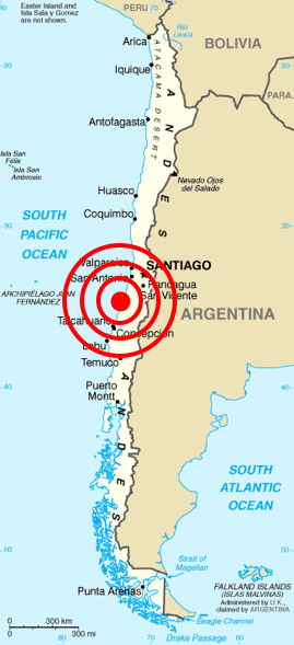
Deutsch: Karte von Chile aus dem CIA World Factbook mit dem Epizentrum des Erdbebens 2010 Chile
Español: Mapa de Chile de la CIA World Factbook, con el epicentro del terremoto de Chile 2010
Français : Carte du Chili de la CIA World Factbook avec l'épicentre du tremblement de terre du Chili 2010
Português: Mapa do Chile da CIA World Factbook, com o epicentro do terremoto do Chile em 2010 |
| วันที่ | (original); 2010-02-27 (This image) |
| แหล่งที่มา | Originally from Central Intelligence Agency's World Factbook. Location of epicenter from BBC |
| ผู้สร้างสรรค์ | Central Intelligence Agency's World Factbook |
| การอนุญาต (การใช้ไฟล์นี้ใหม่) |
PD-USGOV-CIA-WF. |
การอนุญาตใช้สิทธิ
This image is in the public domain because it contains materials that originally came from the United States Central Intelligence Agency's World Factbook.
|
 |
| Annotations | This image is annotated: View the annotations at Commons |
ประวัติไฟล์
คลิกวันที่/เวลาเพื่อดูไฟล์ที่ปรากฏในขณะนั้น
| วันที่/เวลา | รูปย่อ | ขนาด | ผู้ใช้ | ความเห็น | |
|---|---|---|---|---|---|
| ปัจจุบัน | 20:45, 27 กุมภาพันธ์ 2553 | | 269 × 589 (112 กิโลไบต์) | Cargoking | {{Information |Description=Map of en:Chile from [http://www.lib.utexas.edu/maps/cia02/chile_sm02.gif CIA World Factbook] with the epicenter of 2010 Chile earthquake marked. |Source=Originally from Central Intelligence Agen |
หน้าที่มีภาพนี้
หน้าต่อไปนี้ โยงมาที่ภาพนี้:
การใช้ไฟล์ข้ามโครงการ
วิกิอื่นต่อไปนี้ใช้ไฟล์นี้:
- การใช้บน be.wikipedia.org
- การใช้บน bg.wikipedia.org
- การใช้บน ckb.wikipedia.org
- การใช้บน cy.wikipedia.org
- การใช้บน da.wikipedia.org
- การใช้บน en.wikipedia.org
- การใช้บน en.wikinews.org
- การใช้บน eo.wikipedia.org
- การใช้บน es.wikinews.org
- การใช้บน et.wikipedia.org
- การใช้บน fa.wikipedia.org
- การใช้บน fi.wikipedia.org
- การใช้บน fr.wikinews.org
- การใช้บน ja.wikipedia.org
- การใช้บน ka.wikipedia.org
- การใช้บน lt.wikipedia.org
- การใช้บน ml.wikipedia.org
- การใช้บน ms.wikipedia.org
- การใช้บน no.wikinews.org
- การใช้บน pt.wikinews.org
- การใช้บน ro.wikipedia.org
- การใช้บน ro.wikinews.org
- การใช้บน ru.wikipedia.org
- การใช้บน ru.wikinews.org
- การใช้บน sh.wikipedia.org
- การใช้บน simple.wikipedia.org
- การใช้บน sq.wikipedia.org
- การใช้บน sr.wikipedia.org
- การใช้บน sv.wikipedia.org
- การใช้บน ta.wikinews.org
- การใช้บน tr.wikipedia.org
- การใช้บน uk.wikinews.org
- การใช้บน vi.wikipedia.org
- การใช้บน www.wikidata.org
- การใช้บน zh.wikipedia.org