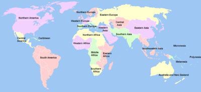
แผนโลกของสหประชาชาติ
บทความรายชื่อวิกิมีเดีย
แผนโลกของสหประชาชาติ (อังกฤษ: United Nations geoscheme) เป็นระบบที่แบ่งประเทศของโลกออกเป็นกลุ่มภูมิภาคและอนุภูมิภาคที่แผนกสถิติสหประชาชาติคิดขึ้นโดยอ้างจากมาตรฐาน UN M.49[1][2][3]

ผู้คิดแผนนี้มีหมายเหตุในการใช้ไว้ว่า "การกำหนดประเทศหรือพื้นที่ให้เป็นกลุ่มเฉพาะนั้นมีไว้เพื่อให้ง่ายกับการบันทึกทางสถิติไม่ได้บ่งบอกถึงข้อสันนิษฐานใด ๆ อันเกี่ยวกับการเมืองหรือความผูกพันอื่น ๆ ของประเทศหรือดินแดน"[4]
รายชื่อภูมิภาคและอนุภูมิภาค แก้
- ทวีปแอฟริกา — ดูเพิ่ม: แผนสำหรับทวีปแอฟริกา
- ทวีปอเมริกา — ดูเพิ่ม: แผนสำหรับทวีปอเมริกา
- * อนุภูมิภาคทั้งสามนี้ร่วมกันเป็นทวีปอเมริกาเหนือในทางภูมิศาสตร์[3]
- ทวีปเอเชีย ** — ดูเพิ่ม: แผนสำหรับทวีปเอเชีย
- ทวีปยุโรป ** — ดูเพิ่ม: แผนสำหรับทวีปยุโรป
- ยุโรปตะวันออก – สหประชาชาติรวมเอเชียเหนือ (ส่วนของรัสเซียที่อยู่ในเอเชีย) เข้ามาอยู่ในภูมิภาคนี้
- ยุโรปเหนือ
- ยุโรปใต้
- ยุโรปตะวันตก
- ** ทั้ง 2 ทวีปนี้ร่วมกันเป็นมหาทวีปยูเรเชียในทางภูมิศาสตร์ ซึ่งไม่ได้รวมในแผนโลกของสหประชาชาติ
แผนที่ แก้
อ้างอิง แก้
- ↑ Ajey Lele (20 October 2012). Asian Space Race: Rhetoric or Reality?. Springer Science & Business Media. pp. 8–. ISBN 978-81-322-0733-7.
Te best option to identify the states from Asia could be use the United Nations (UN) geoscheme for Asia. As per this, Asia is subdivided to four broad categories: Western Asia, .. ...
- ↑ Reuben P. Keller; Marc W. Cadotte; Glenn Sandiford (24 November 2014). Invasive Species in a Globalized World: Ecological, Social, and Legal Perspectives on Policy. University of Chicago Press. pp. 128–. ISBN 978-0-226-16618-6.
- ↑ 3.0 3.1 "United Nations Statistics Division - Standard Country and Area Codes Classifications". คลังข้อมูลเก่าเก็บจากแหล่งเดิมเมื่อ 2011-07-13. สืบค้นเมื่อ 2019-01-05.
- ↑ United Nations Statistics Division - Standard Country and Area Codes Classifications