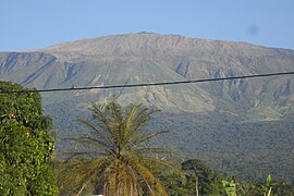
เขาแคเมอรูน
เขาแคเมอรูน (อังกฤษ: Mount Cameroon) ตั้งอยู่ในประเทศแคเมอรูน ใกล้กับอ่าวกินี เป็นภูเขาไฟที่ขนาดใหญ่ลูกหนึ่งในทวีปแอฟริกา มีความสูง 4,095 เมตร
| เขาแคเมอรูน | |
|---|---|
 เขาแคเมอรูน | |
| จุดสูงสุด | |
| ความสูง เหนือระดับน้ำทะเล | 4,040 เมตร (13,255 ฟุต) [1][2] |
| ความสูง ส่วนยื่นจากฐาน | 3,901 เมตร (12,799 ฟุต) [3] อันดับที่ 31 |
| รายชื่อ | จุดสูงสุดของประเทศ Ultra |
| พิกัด | 4°13′00″N 9°10′21″E / 4.21667°N 9.17250°E |
| ข้อมูลทางภูมิศาสตร์ | |
| ที่ตั้ง | ภาคตะวันตกเฉียงใต้ ประเทศแคเมอรูน |
| ข้อมูลทางธรณีวิทยา | |
| ประเภทภูเขา | กรวยภูเขาไฟสลับชั้น |
| การปะทุครั้งล่าสุด | กุมภาพันธ์ ค.ศ. 2012 |
| การพิชิต | |
| พิชิตครั้งแรก | โจเซฟ เมอร์ริก ทศวรรษ 1840[4] |
| เส้นทางง่ายสุด | การปีน |
อ้างอิง แก้
- ↑ A higher elevation of 4,095 m (13,435 ft) is often given, but this is not compatible with SRTM data, which shows no 3" cells higher than 4,027 m (13,212 ft) or 1" cells higher than 4,029 m (13,219 ft).
- ↑ A hand-held GPS reading of 4,045 m (13,271 ft) was reported in 2015.[1] The elevation is subject to change due to volcanic activity.
- ↑ "Mont Cameroun, Cameroon" Peakbagger.com. Retrieved 2012-09-30.
- ↑ DeLancey and DeLancey 174. The authors do not give a precise year, but Merrick was active in Cameroon from 1844 to 1849.
บรรณานุกรม แก้
- DeLancey, M. W. and M. D. DeLancey. (2000). Historical Dictionary of the Republic of Cameroon (3rd ed.). Lanham, Maryland: The Scarecrow Press.
