ฉนวนวาคาน
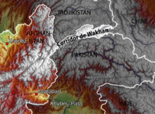
ฉนวนวาคาน (อังกฤษ: Wakhan Corridor; ปาทาน: واخان دهلېز, อักษรโรมัน: wāxān dahléz; เปอร์เซีย: دالان واخان, อักษรโรมัน: dâlân vâxân) เป็นช่องดินแดนแคบในประเทศอัฟกานิสถานที่ยื่นออกไปจรดประเทศจีน และแยกภูมิภาคปกครองตนเองกอร์โน-บาดัคชานของทาจิกิสถานจากกิลกิต-บัลติสถานในกัศมีร์ส่วนที่บริหารโดยปากีสถาน[1][2][3][4] มีเทือกเขาปามีร์อยู่ทางทิศเหนือ และเทือกเขาการาโกรัมทางทิศใต้ ฉนวนวาคานเป็นต้นแม่น้ำปันจ์และแม่น้ำปามีร์ ซึ่งไหลมารวมกันกลายเป็นแม่น้ำอามูดาร์ยา นักเดินทางใช้เส้นทางการค้าผ่านหุบเขานี้ไปยังเอเชียตะวันออก, เอเชียใต้ และเอเชียกลางมาตั้งแต่สมัยโบราณ[5]
| ฉนวนวาคาน | |||||||||||||
 ฉนวนวาคาน | |||||||||||||
 | |||||||||||||
| ชื่อภาษาจีน | |||||||||||||
|---|---|---|---|---|---|---|---|---|---|---|---|---|---|
| อักษรจีนตัวย่อ | 瓦罕走廊 | ||||||||||||
| อักษรจีนตัวเต็ม | 瓦罕走廊 | ||||||||||||
| ความหมายตามตัวอักษร | ฉนวนวาคาน | ||||||||||||
| |||||||||||||
| ชื่อภาษาจีนอื่น ๆ | |||||||||||||
| อักษรจีนตัวย่อ | 阿富汗走廊 | ||||||||||||
| อักษรจีนตัวเต็ม | 阿富汗走廊 | ||||||||||||
| ความหมายตามตัวอักษร | ฉนวนอัฟกัน | ||||||||||||
| |||||||||||||
| ชื่อภาษาจีนอื่น ๆ (2) | |||||||||||||
| อักษรจีนตัวย่อ | 瓦罕帕米尔 | ||||||||||||
| อักษรจีนตัวเต็ม | 瓦罕帕米爾 | ||||||||||||
| ความหมายตามตัวอักษร | วาคานปามีร์ | ||||||||||||
| |||||||||||||
| ชื่อดารี | |||||||||||||
| ดารี | دالان واخان | ||||||||||||
ฉนวนนี้ได้รับการจัดตั้งขึ้นตามข้อตกลงใน ค.ศ. 1893 ระหว่างจักรวรรดิบริติช (บริติชราช) กับอัฟกานิสถาน ก่อให้เกิดเส้นดูรันด์[6] ช่องดินแดนแคบทำหน้าที่เป็นเขตกันชนระหว่างจักรวรรดิรัสเซียกับจักรวรรดิบริติช ฝั่งตะวันออกติดกับซินเจียงของจีนสมัยราชวงศ์ชิง
ในทางการเมือง ฉนวนนี้อยู่ในอำเภอวาคาน จังหวัดบาดัคชาน ประเทศอัฟกานิสถาน ใน ค.ศ. 2010 ฉนวนวาคานมีประชากร 12,000 คน[7]
อ้างอิง แก้
- ↑ Bruce Elleman; Stephen Kotkin; Clive Schofield (18 May 2015). Beijing's Power and China's Borders: Twenty Neighbors in Asia. M.E. Sharpe. pp. 13–. ISBN 978-0-7656-2766-7.
The Sino-Afghan border was delimited in a secret treaty signed during November 1963. The corridor shares a border with Pakistan to its south and Tajikistan to its north.
- ↑ Pervaiz I Cheema; Manuel Riemer (22 August 1990). Pakistan's Defence Policy 1947-58. Palgrave Macmillan UK. pp. 46–. ISBN 978-1-349-20942-2.
In addition, the Soviet Union is separated from Pakistani territory by a small strip commonly known as the Wakhan corridor. Theoretically the Soviet Union does not have a common border with Pakistan but in view of their close linkage with Afghanistan and the shortness of Wakhan's breadth make it an immediate neighbour for all practical purposes.
- ↑ Yasmeen Niaz Mohiuddin (2007). Pakistan: A Global Studies Handbook. ABC-CLIO. pp. 18–. ISBN 978-1-85109-801-9.
The Chitral and Kalash valleys of the Hindu Kush Mountains are located north of the Swat Valley in the Chitral district of the North-West Frontier Province and are bordered by Afghanistan on the north, south, and west. The Wakhan Corridor separates Pakistan from Tajikistan.The corridor, wedged between the Pamir Mountains to the north and the Karakoram range to the south, is about 350 km (220 mi) long and 13–65 กิโลเมตร (8–40 ไมล์) wide.
- ↑ International Boundary Study of the Afghanistan–USSR Boundary (1983) by the US Bureau of Intelligence and Research Pg. 7. Archived on 2011-06-07
- ↑ "Wakhan Corridor travel guide". Caravanistan (ภาษาอังกฤษแบบอเมริกัน). สืบค้นเมื่อ 29 October 2018.
{{cite web}}: CS1 maint: url-status (ลิงก์) - ↑ Nystrop, Richard F. And Donald M. Seekins, eds. Afghanistan a Country Study. Washington: Library of Congress, 1986, p. 38.
- ↑ Wong, Edward (27 October 2010). "In Icy Tip of Afghanistan, War Seems Remote". The New York Times. สืบค้นเมื่อ 28 October 2010.