ไฟล์:Tonlesap.jpg
ขนาดของตัวอย่างนี้: 597 × 599 พิกเซล ความละเอียดอื่น: 239 × 240 พิกเซล | 478 × 480 พิกเซล | 765 × 768 พิกเซล | 1,020 × 1,024 พิกเซล | 2,039 × 2,048 พิกเซล | 4,079 × 4,096 พิกเซล
ดูภาพที่มีความละเอียดสูงกว่า (4,079 × 4,096 พิกเซล, ขนาดไฟล์: 17.17 เมกะไบต์, ชนิดไมม์: image/jpeg)
| รูปภาพหรือไฟล์เสียงนี้ ต้นฉบับอยู่ที่ คอมมอนส์ รายละเอียดด้านล่าง เป็นข้อความที่แสดงผลจาก ไฟล์ต้นฉบับในคอมมอนส์
|
| คำอธิบาย |
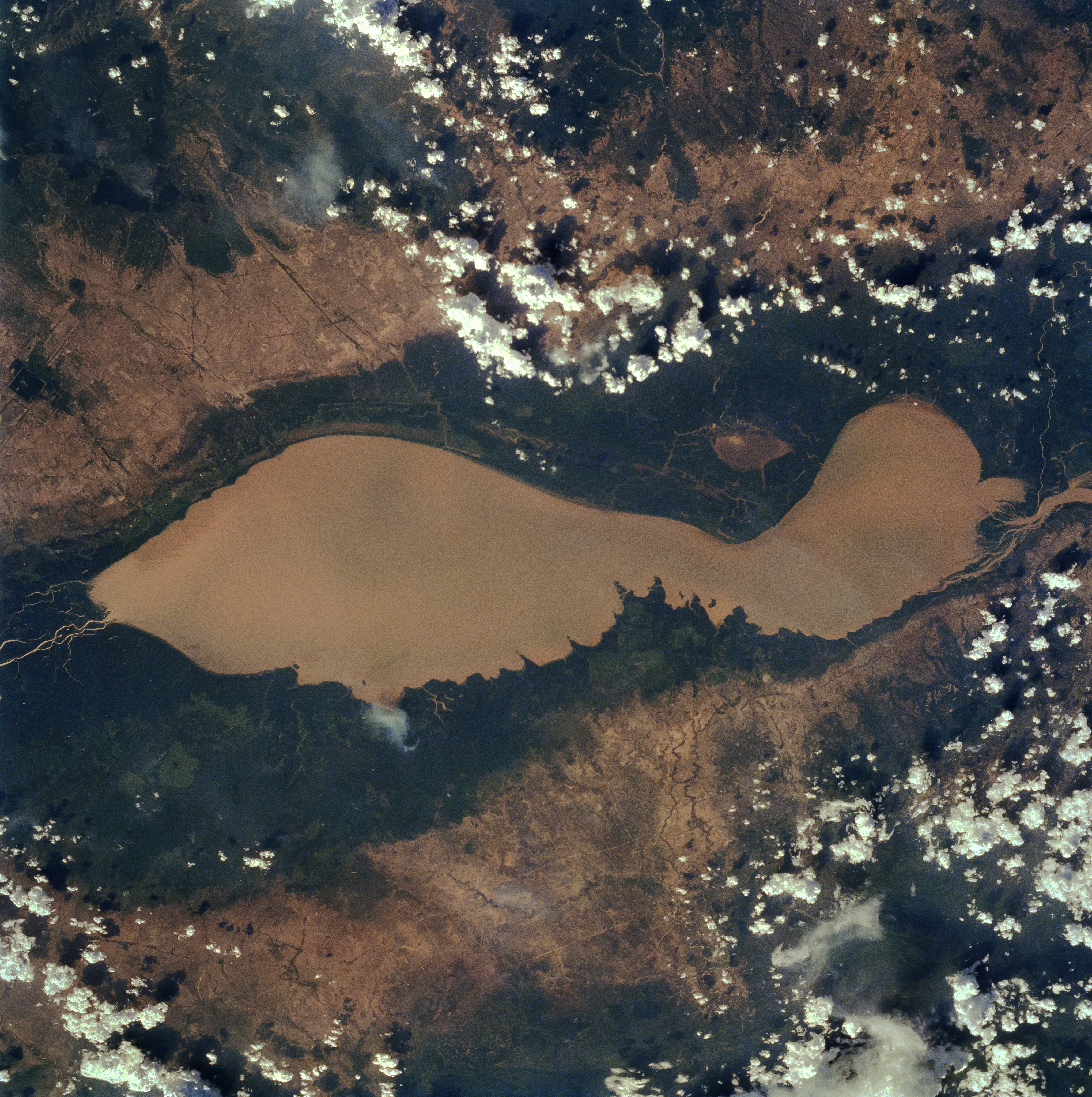
English: The Tonle Sap (also know as the Great Lake) occupies a depression in the Cambodian Plain and is a shallow silt-laden lake. It is the largest lake in Southeast Asia and is fed by many streams. The Tonle Sap is drained by the Tonle Sab River (upper center), which flows south-southeast to the Mekong River (not visible on the image). The river connecting the Tonle Sap with the Mekong creates a unique phenomenon not known in any other part of the world: reversing its direction of flow twice a year. For most of the time, the Tonle Sab River flows from the lake to the Mekong River near the capital city of Phnom Penh. However, during the Southeast Asian monsoon season from June to November, when the Mekong drains large areas of Southeast Asia, the Tonle Sab flows from the Mekong back into the Tonle Sap. During the monsoon season, the Tonle Sap increases from 1000 sq. miles (2600 sq. km) to near 4020 sq. miles (10400 sq. km) raising the lake level 30 feet (9 meters), causing enormous floods in the region surrounding the lake. |
| วันที่ | |
| แหล่งที่มา |
Earth from Space - Image Information Gateway to Astronaut Photography of Earth |
| ผู้สร้างสรรค์ | NASA/Johnson Space Center |
| การอนุญาต (การใช้ไฟล์นี้ใหม่) |
PD-USGov-NASA |
This image or video was catalogued by one of the centers of the United States National Aeronautics and Space Administration (NASA) under Photo ID: STS059-84-80. This tag does not indicate the copyright status of the attached work. A normal copyright tag is still required. See Commons:Licensing. Other languages:
|
| ภาพนี้เป็นสาธารณสมบัติ เนื่องจากเป็นภาพที่สร้างขึ้นโดยองค์การบริหารการบินและอวกาศแห่งชาติ (NASA) ซึ่งตามนโยบายด้านลิขสิทธิ์ของนาซาระบุไว้ว่า "ภาพและสื่อต่าง ๆ ของนาซาไม่ได้รับการคุ้มครองโดยลิขสิทธิ์ยกเว้นจะระบุไว้ว่ามีลิขสิทธิ์" ดูเพิ่มที่ หน้านโยบายด้านลิขสิทธิ์ของนาซา หรือ นโยบายการใช้ภาพของ JPL | ||
 |
คำเตือน:
|
ประวัติไฟล์
คลิกวันที่/เวลาเพื่อดูไฟล์ที่ปรากฏในขณะนั้น
| วันที่/เวลา | รูปย่อ | ขนาด | ผู้ใช้ | ความเห็น | |
|---|---|---|---|---|---|
| ปัจจุบัน | 17:40, 4 เมษายน 2565 | | 4,079 × 4,096 (17.17 เมกะไบต์) | Tiouraren | larger version |
| 13:48, 15 กรกฎาคม 2558 |  | 902 × 695 (293 กิโลไบต์) | Wikirictor | i re-sized it, enhanced its quality and rotated it in order to have north on top. | |
| 12:04, 18 มิถุนายน 2549 |  | 637 × 640 (53 กิโลไบต์) | Georgio~commonswiki | {{Information |Description=Earth Sciences and Image Analysis, NASA-Johnson Space Center. 16 Apr. 2004. "Earth from Space - Image Information." |Source=http://earth.jsc.nasa.gov/sseop/efs/photoinfo.pl?PHOTO=STS059-84-80 |Date=16 Apr. 2004. |Author=NASA |Pe |
หน้าที่มีภาพนี้
หน้าต่อไปนี้ โยงมาที่ภาพนี้:
การใช้ไฟล์ข้ามโครงการ
วิกิอื่นต่อไปนี้ใช้ไฟล์นี้:
- การใช้บน af.wikipedia.org
- การใช้บน ar.wikipedia.org
- การใช้บน az.wikipedia.org
- การใช้บน bg.wikipedia.org
- การใช้บน ca.wikipedia.org
- การใช้บน ceb.wikipedia.org
- การใช้บน cv.wikipedia.org
- การใช้บน cy.wikipedia.org
- การใช้บน en.wikipedia.org
- การใช้บน en.wikivoyage.org
- การใช้บน eo.wikipedia.org
- การใช้บน es.wikipedia.org
- การใช้บน eu.wikipedia.org
- การใช้บน he.wikivoyage.org
- การใช้บน id.wikipedia.org
- การใช้บน it.wikipedia.org
- การใช้บน it.wikivoyage.org
- การใช้บน ja.wikipedia.org
- การใช้บน ka.wikipedia.org
- การใช้บน ko.wikipedia.org
- การใช้บน ms.wikipedia.org
- การใช้บน my.wikipedia.org
- การใช้บน no.wikipedia.org
- การใช้บน pl.wikipedia.org
- การใช้บน ru.wikipedia.org
- การใช้บน sh.wikipedia.org
- การใช้บน sv.wikipedia.org
- การใช้บน te.wikipedia.org
- การใช้บน tl.wikipedia.org
- การใช้บน uk.wikipedia.org
- การใช้บน ur.wikipedia.org
- การใช้บน vi.wikipedia.org
- การใช้บน war.wikipedia.org
- การใช้บน www.wikidata.org
- การใช้บน zh-yue.wikipedia.org
- การใช้บน zh.wikipedia.org