ไฟล์:Ottoman Empire Administrative Divisions.png
ขนาดของตัวอย่างนี้: 552 × 600 พิกเซล ความละเอียดอื่น: 221 × 240 พิกเซล | 442 × 480 พิกเซล | 707 × 768 พิกเซล | 943 × 1,024 พิกเซล | 1,885 × 2,048 พิกเซล | 4,455 × 4,840 พิกเซล
ดูภาพที่มีความละเอียดสูงกว่า (4,455 × 4,840 พิกเซล, ขนาดไฟล์: 2.1 เมกะไบต์, ชนิดไมม์: image/png)
| รูปภาพหรือไฟล์เสียงนี้ ต้นฉบับอยู่ที่ คอมมอนส์ รายละเอียดด้านล่าง เป็นข้อความที่แสดงผลจาก ไฟล์ต้นฉบับในคอมมอนส์
|
ความย่อ
| คำอธิบาย |
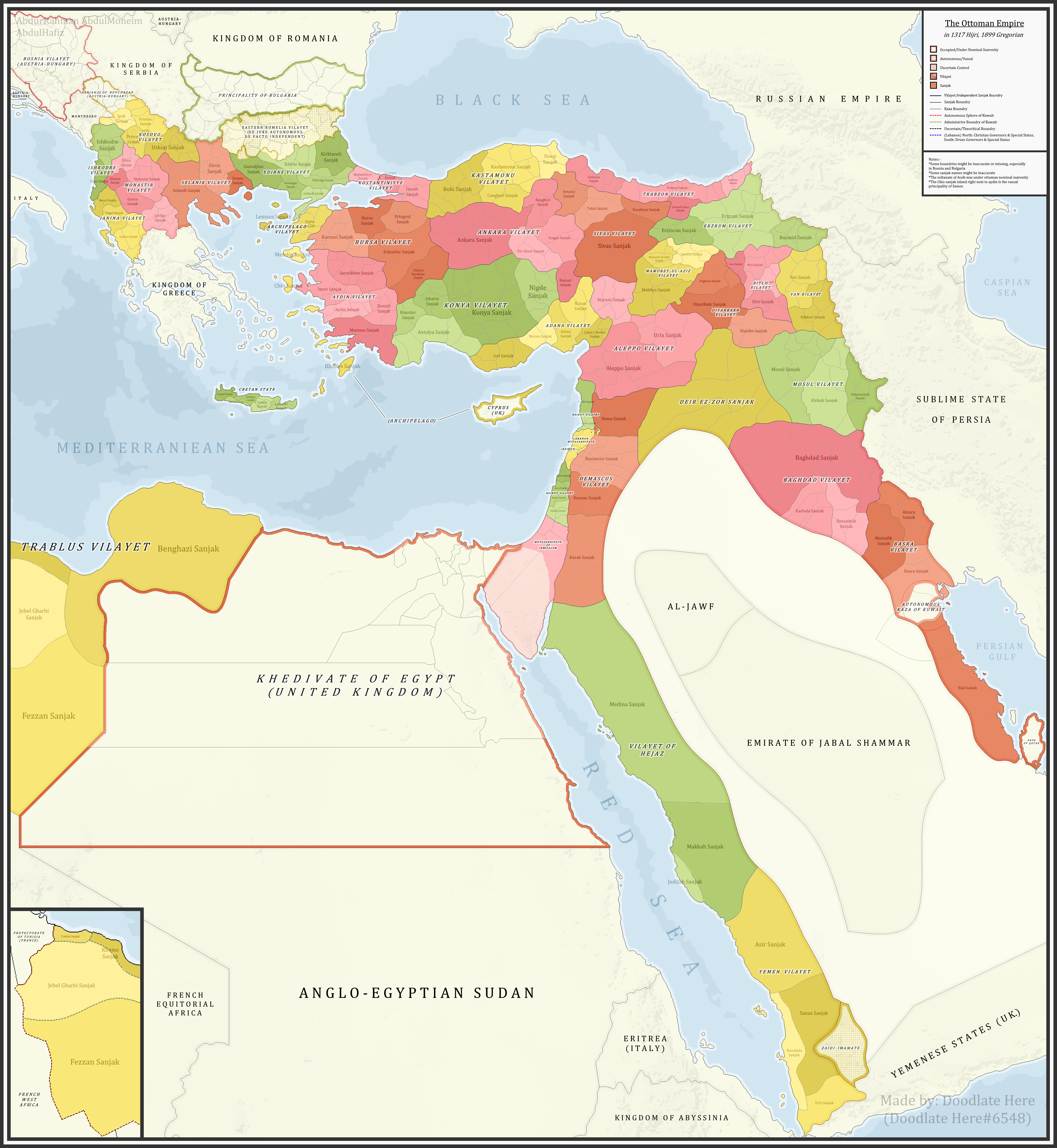
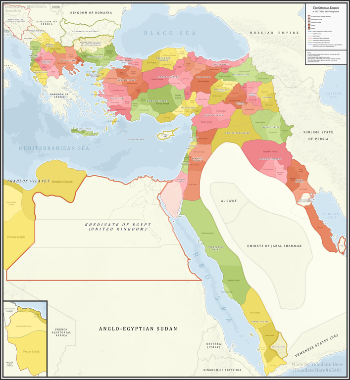
English: A detailed map showing the Ottoman Empire and its dependencies, including its administrative divisions, in 1899 CE (1317 Hijri). |
| วันที่ | |
| แหล่งที่มา |
งานของตัว References:The sources that back up the maps are as follows: [1] Pavet de Courteille, Abel (1876). État présent de l'empire ottoman (in French). J. Dumaine. pp. 91–96. (for Yemen) [2] http://tarihvemedeniyet.org/2009/10/trablus-garb-vilayeti.html for Tripolitania [3] http://tarihvemedeniyet.org/2009/10/bosna-vilayeti.html for Bosnia [4] https://www.nsi.bg/nrnm/index.php?i=1&ezik=en for eastern Rumelia [5] http://hdl.loc.gov/loc.gmd/g7431f.ct002181 (Rest of Ottoman subdivisions, taken from the United States Library of Congress's Geography & Map Division, digital ID g7431f.ct002181) |
| ผู้สร้างสรรค์ | AbdurRahman AbdulMoneim |
| เวอร์ชันอื่น |

การอนุญาตใช้สิทธิ
ข้าพเจ้า ในฐานะผู้ถือลิขสิทธิ์ของภาพหรือสื่อนี้ อนุญาตให้ใช้ภาพหรือสื่อนี้ภายใต้เงื่อนไขต่อไปนี้
ไฟล์นี้อยู่ภายใต้สัญญาอนุญาต ครีเอทีฟคอมมอนส์ แบบแสดงที่มา-อนุญาตแบบเดียวกัน 4.0 นานาชาติ
- คุณสามารถ:
- ที่จะแบ่งปัน – ที่จะทำสำเนา แจกจ่าย และส่งงานดังกล่าวต่อไป
- ที่จะเรียบเรียงใหม่ – ที่จะดัดแปลงงานดังกล่าว
- ภายใต้เงื่อนไขต่อไปนี้:
- แสดงที่มา – คุณต้องให้เกียรติเจ้าของงานอย่างเหมาะสม โดยเพิ่มลิงก์ไปยังสัญญาอนุญาต และระบุหากมีการเปลี่ยนแปลง คุณอาจทำเช่นนี้ได้ในรูปแบบใดก็ได้ตามควร แต่ต้องไม่ใช่ในลักษณะที่แนะว่าผู้ให้อนุญาตสนับสนุนคุณหรือการใช้งานของคุณ
- อนุญาตแบบเดียวกัน – หากคุณดัดแปลง เปลี่ยนรูป หรือต่อเติมงานนี้ คุณต้องใช้สัญญาอนุญาตแบบเดียวกันหรือแบบที่เหมือนกับสัญญาอนุญาตที่ใช้กับงานนี้เท่านั้น
| Annotations | This image is annotated: View the annotations at Commons |
ประวัติไฟล์
คลิกวันที่/เวลาเพื่อดูไฟล์ที่ปรากฏในขณะนั้น
| วันที่/เวลา | รูปย่อ | ขนาด | ผู้ใช้ | ความเห็น | |
|---|---|---|---|---|---|
| ปัจจุบัน | 14:16, 16 พฤศจิกายน 2564 | | 4,455 × 4,840 (2.1 เมกะไบต์) | BasilLeaf | updates |
| 02:22, 6 พฤษภาคม 2564 |  | 4,455 × 4,840 (2.11 เมกะไบต์) | Super Dromaeosaurus | Romanian Black Sea Snake Island, Romanian-Russian border at Dobruja-Bessarabia, removed lands in Banat that didn't belong to Romania then | |
| 01:17, 15 เมษายน 2564 |  | 4,455 × 4,840 (2.03 เมกะไบต์) | محمد٢ | Reverted to version as of 18:40, 19 January 2021 (UTC) | |
| 09:05, 8 กุมภาพันธ์ 2564 |  | 4,455 × 4,840 (2.1 เมกะไบต์) | BasilLeaf | Minor name fixes. Iran's official English name was "Sublime State of Persia". "Arab Gulf" Doesn't exist. There's "Arabian Gulf", a name that only came to decently widespread usage from 1960s. Contemporary internationally accepted term is "Persian Gulf". | |
| 01:40, 20 มกราคม 2564 |  | 4,455 × 4,840 (2.03 เมกะไบต์) | Userd898 | minor edit regarding the recoloring of a wrongly colored spot in haasa | |
| 01:05, 20 มกราคม 2564 |  | 4,455 × 4,840 (2.03 เมกะไบต์) | Userd898 | fixed some mistakes in yemen and labeled qatar as occupied source: https://www.euratlas.net/history/hisatlas/arabia/1904__AR.html | |
| 01:48, 15 มกราคม 2564 |  | 4,455 × 4,840 (2.1 เมกะไบต์) | BasilLeaf | Minor name fixes. Iran's official English name was "Sublime State of Persia". "Arab Gulf" Doesn't exist. There's "Arabian Gulf", a name that only came to decently widespread usage in 1960s. | |
| 02:15, 28 ธันวาคม 2563 |  | 4,455 × 4,840 (2.03 เมกะไบต์) | Userd898 | Uploaded own work with UploadWizard |
หน้าที่มีภาพนี้
หน้าต่อไปนี้ โยงมาที่ภาพนี้:
การใช้ไฟล์ข้ามโครงการ
วิกิอื่นต่อไปนี้ใช้ไฟล์นี้:
- การใช้บน bg.wikipedia.org
- การใช้บน bn.wikipedia.org
- การใช้บน ca.wikipedia.org
- การใช้บน ckb.wikipedia.org
- การใช้บน de.wikipedia.org
- การใช้บน el.wikipedia.org
- การใช้บน en.wikipedia.org
- Ottoman Empire
- Sanjak
- Administrative divisions of the Ottoman Empire
- Kosovo vilayet
- Baghdad vilayet
- Mosul vilayet
- Scutari vilayet
- Basra vilayet
- Ottoman Tripolitania
- Ottoman Syria
- Abdul Hamid II
- Ottoman Iraq
- Mount Lebanon Mutasarrifate
- Janina vilayet
- Beirut vilayet
- Syria vilayet
- Hejaz vilayet
- Talk:Greater Palestine
- User:Falcaorib/Contemporary Empires (1800-2024 AD)
- การใช้บน es.wikipedia.org
- การใช้บน fa.wikipedia.org
- การใช้บน fi.wikipedia.org
- การใช้บน fr.wikipedia.org
- การใช้บน gl.wikipedia.org
- การใช้บน he.wikipedia.org
- การใช้บน it.wikipedia.org
ดูการใช้ข้ามโครงการเพิ่มเติมของไฟล์นี้