ไฟล์:Nishioizumi-machi, CKT20176-C29-3.png

ขนาดของตัวอย่างนี้: 660 × 599 พิกเซล ความละเอียดอื่น: 264 × 240 พิกเซล | 529 × 480 พิกเซล | 846 × 768 พิกเซล | 1,087 × 987 พิกเซล
ดูภาพที่มีความละเอียดสูงกว่า (1,087 × 987 พิกเซล, ขนาดไฟล์: 1.69 เมกะไบต์, ชนิดไมม์: image/png)
| รูปภาพหรือไฟล์เสียงนี้ ต้นฉบับอยู่ที่ คอมมอนส์ รายละเอียดด้านล่าง เป็นข้อความที่แสดงผลจาก ไฟล์ต้นฉบับในคอมมอนส์
|
ความย่อ
| คำอธิบาย |
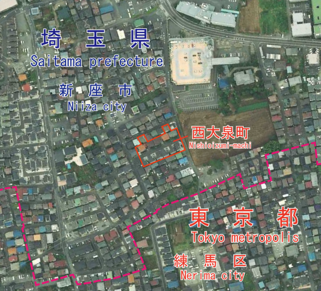
日本語: 東京都練馬区西大泉町付近の空中写真。都県境はGoogle Mapを参照して引いたものであり、正確な境界線を必要とする場合は、公図を参照してください。
English: An aerial photo of Nishioizumi-machi, Nerima, Tokyo, Japan. I drew the boundary of Saitama pref. and Tokyo metro. by data of google map. If you need more accurate boundary line, please refer to a public map. |
| วันที่ | Taken on 23 สิงหาคม พ.ศ. 2560 |
| แหล่งที่มา |
日本語: 国土画像情報(カラー空中写真)(整理番号:CKT20176、コース番号:C29、写真番号:3、撮影年月日:2017年8月23日、撮影地域:東京、撮影高度:2197m、数値写真レベル:10000、カメラ名称:DMC2e-230、焦点距離:92.020mm、カラー種別:カラー、写真種別:デジタル、撮影計画機関:国土地理院、市区町村名:練馬区)https://mapps.gsi.go.jp/contentsImageDisplay.do?specificationId=1821347&isDetail=true
English: National Land Image Information (Color Aerial Photographs) (Reference number: CKT20176; Course Number: C29; Photo Number: 3; Date: August 23, 2017; Area: Tokyo; Height: 2197 metre; Numeric Photo Level: 10000; Camera Name: DMC2e-230; Focal distance: 92.020 millimetre; Color Type: Color; Photo Type: Digital; Agency: Geographical Survey Institute of Japan; Municipality: Nerima City) https://mapps.gsi.go.jp/contentsImageDisplay.do?specificationId=1821347&isDetail=true |
| ผู้สร้างสรรค์ |
English: Geographical Survey Institute of Japan 日本語: 国土地理院 |
การอนุญาตใช้สิทธิ

|
Ministry of Land, Infrastructure, Transport and Tourism ซึ่งเป็นผู้ถือลิขสิทธิ์ของไฟล์นี้ อนุญาตให้นำไฟล์นี้ไปใช้ได้ในทุกวัตถุประสงค์ รวมไปถึงการทำซ้ำ การนำไฟล์นี้ไปใช้ในการสร้างไฟล์ใหม่ การใช้เพื่อการค้า และการใช้อื่น ๆ โดยมีเงื่อนไขว่า ต้องระบุชื่อผู้ถือลิขสิทธิ์ของไฟล์นี้อย่างเหมาะสมเมื่อนำไฟล์นี้ไปใช้ |
การแสดงที่มา:
National Land Image Information (Color Aerial Photographs), created by Ministry of Land, Infrastructure, Transport and Tourism, distributed by Geospatial Information Authority of Japan
|

ประวัติไฟล์
คลิกวันที่/เวลาเพื่อดูไฟล์ที่ปรากฏในขณะนั้น
| วันที่/เวลา | รูปย่อ | ขนาด | ผู้ใช้ | ความเห็น | |
|---|---|---|---|---|---|
| ปัจจุบัน | 20:29, 5 มิถุนายน 2564 | | 1,087 × 987 (1.69 เมกะไบต์) | Miyuki Meinaka | Uploaded a work by {{en|1=Geographical Survey Institute of Japan}}{{ja|1=国土地理院}} from {{ja|1=国土画像情報(カラー空中写真)(整理番号:CKT20176、コース番号:C29、写真番号:3、撮影年月日:2017年8月23日、撮影地域:東京、撮影高度:2197m、数値写真レベル:10000、カメラ名称:DMC2e-230、焦点距離:92.020mm、カラー種別:カラー、写真種別:デジタル、撮影計画機関:国土地理院、市区町村名:練馬区)https://mapps.gsi.go.jp/contentsImageDisplay.do?specificationId=1821347&isDetail=true}} {{en|1=National Land Image Information (Color Aerial Photographs) (Reference number: CKT20176; Course Number: C29; Photo Number: 3; Date: August 2... |
หน้าที่มีภาพนี้
หน้าต่อไปนี้ โยงมาที่ภาพนี้:
การใช้ไฟล์ข้ามโครงการ
วิกิอื่นต่อไปนี้ใช้ไฟล์นี้:
- การใช้บน en.wikipedia.org
- การใช้บน ja.wikipedia.org
- การใช้บน zh.wikipedia.org