ไฟล์:Newyork heat island.jpg

ขนาดของตัวอย่างนี้: 298 × 598 พิกเซล ความละเอียดอื่น: 119 × 240 พิกเซล | 540 × 1,084 พิกเซล
ดูภาพที่มีความละเอียดสูงกว่า (540 × 1,084 พิกเซล, ขนาดไฟล์: 149 กิโลไบต์, ชนิดไมม์: image/jpeg)
| รูปภาพหรือไฟล์เสียงนี้ ต้นฉบับอยู่ที่ คอมมอนส์ รายละเอียดด้านล่าง เป็นข้อความที่แสดงผลจาก ไฟล์ต้นฉบับในคอมมอนส์
|
ความย่อ
| คำอธิบาย |
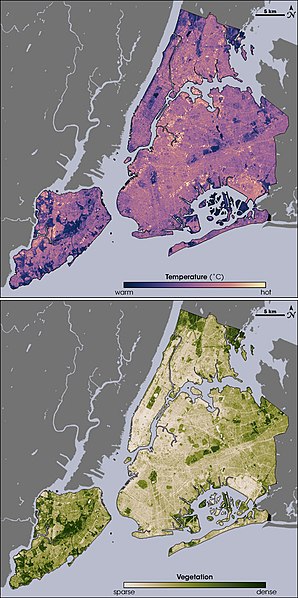
English: Thermal infrared satellite data measured by NASAâs Landsat Enhanced Thematic Mapper Plus on August 14, 2002 one of the hottest days in New York City's summer. Landsat also collected vegetation data. Image from NASA EArth Observatory web page <http://earthobservatory.nasa.gov/Newsroom/NewImages/images.php3?img_id=17354> --Ryanjo 23:43, 1 August 2006 (UTC) |
| แหล่งที่มา | NASA |
| ผู้สร้างสรรค์ | |
| เวอร์ชันอื่น |
 |
การอนุญาตใช้สิทธิ
| ภาพนี้เป็นสาธารณสมบัติ เนื่องจากเป็นภาพที่สร้างขึ้นโดยองค์การบริหารการบินและอวกาศแห่งชาติ (NASA) ซึ่งตามนโยบายด้านลิขสิทธิ์ของนาซาระบุไว้ว่า "ภาพและสื่อต่าง ๆ ของนาซาไม่ได้รับการคุ้มครองโดยลิขสิทธิ์ยกเว้นจะระบุไว้ว่ามีลิขสิทธิ์" ดูเพิ่มที่ หน้านโยบายด้านลิขสิทธิ์ของนาซา หรือ นโยบายการใช้ภาพของ JPL | ||
 |
คำเตือน:
|
บันทึกการอัพโหลด
The original description page was here. All following user names refer to en.wikipedia.
- 2006-08-01 23:43 Ryanjo 540×1084× (152802 bytes) Thermal infrared satellite data measured by NASAâs Landsat Enhanced Thematic Mapper Plus on August 14, 2002 one of the hottest days in New York City's summer. Landsat also collected vegetation data. Image from NASA EArth Observatory web page <http://ear
ประวัติไฟล์
คลิกวันที่/เวลาเพื่อดูไฟล์ที่ปรากฏในขณะนั้น
| วันที่/เวลา | รูปย่อ | ขนาด | ผู้ใช้ | ความเห็น | |
|---|---|---|---|---|---|
| ปัจจุบัน | 21:49, 23 กุมภาพันธ์ 2552 | | 540 × 1,084 (149 กิโลไบต์) | File Upload Bot (Magnus Manske) | {{BotMoveToCommons|en.wikipedia|year={{subst:CURRENTYEAR}}|month={{subst:CURRENTMONTHNAME}}|day={{subst:CURRENTDAY}}}} {{Information |Description={{en|Thermal infrared satellite data measured by NASAâs Landsat Enhanced Thematic Mapper Plus on August |
หน้าที่มีภาพนี้
หน้าต่อไปนี้ โยงมาที่ภาพนี้:
การใช้ไฟล์ข้ามโครงการ
วิกิอื่นต่อไปนี้ใช้ไฟล์นี้:
- การใช้บน af.wikipedia.org
- การใช้บน ca.wikipedia.org
- การใช้บน da.wikipedia.org
- การใช้บน en.wikipedia.org
- การใช้บน eo.wikipedia.org
- การใช้บน et.wikipedia.org
- การใช้บน fa.wikipedia.org
- การใช้บน fr.wikipedia.org
- การใช้บน fr.wikibooks.org
- การใช้บน he.wikipedia.org
- การใช้บน hr.wikipedia.org
- การใช้บน ja.wikipedia.org
- การใช้บน ko.wikipedia.org
- การใช้บน ms.wikipedia.org
- การใช้บน nn.wikipedia.org
- การใช้บน ta.wikipedia.org
- การใช้บน zh.wikipedia.org