ไฟล์:Map Dusit.png

ขนาดของตัวอย่างนี้: 424 × 600 พิกเซล ความละเอียดอื่น: 170 × 240 พิกเซล | 339 × 480 พิกเซล | 543 × 768 พิกเซล | 724 × 1,024 พิกเซล | 1,526 × 2,158 พิกเซล
ดูภาพที่มีความละเอียดสูงกว่า (1,526 × 2,158 พิกเซล, ขนาดไฟล์: 1,023 กิโลไบต์, ชนิดไมม์: image/png)
| รูปภาพหรือไฟล์เสียงนี้ ต้นฉบับอยู่ที่ คอมมอนส์ รายละเอียดด้านล่าง เป็นข้อความที่แสดงผลจาก ไฟล์ต้นฉบับในคอมมอนส์
|
ความย่อ
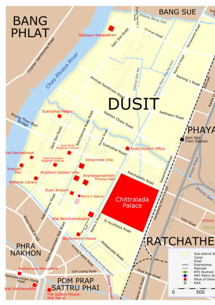
| คำอธิบาย | Map of Dusit District, Bangkok. |
| วันที่ | |
| แหล่งที่มา | Own creation |
| ผู้สร้างสรรค์ | Lerdsuwa |
| การอนุญาต (การใช้ไฟล์นี้ใหม่) |
GFDL |
| เวอร์ชันอื่น | Image:Map Dusit src eng.svg (SVG source) |
การอนุญาตใช้สิทธิ
ข้าพเจ้า ในฐานะผู้ถือลิขสิทธิ์ของภาพหรือสื่อนี้ อนุญาตให้ใช้ภาพหรือสื่อนี้ภายใต้เงื่อนไขต่อไปนี้

|
อนุญาตให้คัดลอก แจกจ่ายและ/หรือดัดแปรเอกสารนี้ภายใต้เงื่อนไขของสัญญาอนุญาตเอกสารเสรีของกนู รุ่น 1.2 หรือรุ่นใด ๆ นับจากนี้ที่ออกโดยมูลนิธิซอฟต์แวร์เสรี โดยไม่มีส่วนใดห้ามแก้ไข ไม่มีข้อความปกหน้าและปกหลัง สำเนาของสัญญาอนุญาตรวมอยู่ในส่วนชื่อ สัญญาอนุญาตเอกสารเสรีของกนู |
| ไฟล์นี้อยู่ภายใต้สัญญาอนุญาต ครีเอทีฟคอมมอนส์ แบบแสดงที่มา-อนุญาตแบบเดียวกัน 3.0 ต้นฉบับ | ||
| ||
| ป้ายแสดงสถานะลิขสิทธิ์นี้ถูกเพิ่มเพื่อให้เป็นไปตามการเปลี่ยนแปลงสัญญาอนุญาตของมูลนิธิวิกิมีเดีย จาก GFDL ไปยัง GFDL ควบคู่กับ CC-BY-SA 3.0 |
ประวัติไฟล์
คลิกวันที่/เวลาเพื่อดูไฟล์ที่ปรากฏในขณะนั้น
| วันที่/เวลา | รูปย่อ | ขนาด | ผู้ใช้ | ความเห็น | |
|---|---|---|---|---|---|
| ปัจจุบัน | 09:10, 30 มกราคม 2563 | | 1,526 × 2,158 (1,023 กิโลไบต์) | Sodacan | Dusit Zoo is gone, Royal Turf Club is gone, National Assembly has moved to Sappaya-Sapasathan, Added Amphorn Sathan Villa |
| 15:37, 12 สิงหาคม 2554 |  | 1,526 × 1,869 (959 กิโลไบต์) | Lerdsuwa | Improve railway | |
| 22:58, 10 ตุลาคม 2549 |  | 1,526 × 1,869 (939 กิโลไบต์) | Lerdsuwa | == Summary == {{Information |Description=Map of Dusit District, Bangkok. |Source=Own creation |Date=10 October 2006 |Author=Lerdsuwa |Permission=GFDL |other_versions=Image:Map Dusit src eng.svg (SVG source) }} == Licensing == { |
หน้าที่มีภาพนี้
ไม่มีหน้าใดโยงมาที่ภาพนี้
การใช้ไฟล์ข้ามโครงการ
วิกิอื่นต่อไปนี้ใช้ไฟล์นี้:
- การใช้บน de.wikipedia.org
- การใช้บน fr.wikipedia.org
- การใช้บน it.wikipedia.org
- การใช้บน ms.wikipedia.org