ไฟล์:Kashmir Region (2020 skirmish locations).jpg
ขนาดของตัวอย่างนี้: 604 × 599 พิกเซล ความละเอียดอื่น: 242 × 240 พิกเซล | 484 × 480 พิกเซล | 774 × 768 พิกเซล | 1,033 × 1,024 พิกเซล | 1,579 × 1,566 พิกเซล
ดูภาพที่มีความละเอียดสูงกว่า (1,579 × 1,566 พิกเซล, ขนาดไฟล์: 1.27 เมกะไบต์, ชนิดไมม์: image/jpeg)
| รูปภาพหรือไฟล์เสียงนี้ ต้นฉบับอยู่ที่ คอมมอนส์ รายละเอียดด้านล่าง เป็นข้อความที่แสดงผลจาก ไฟล์ต้นฉบับในคอมมอนส์
|
.jpg)
ความย่อ
| คำอธิบาย |
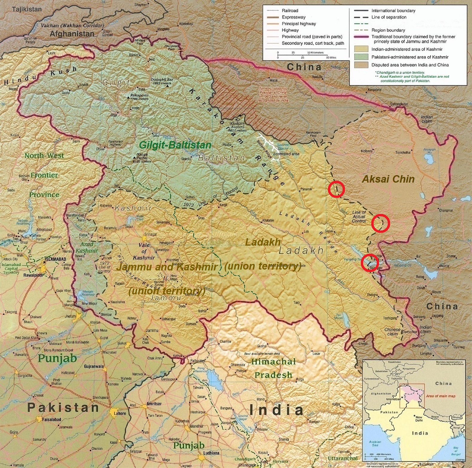
English: A map of the disputed Kashmir region created by the United States CIA in 2004 and hosted by the University of Texas at Austin Perry-Castañeda Library Map Collection; altered to show new jurisdictions by Fowler&fowler in November 2019; altered by to show 2020 skirmish locations by MarkH21 in June 2020. The red circles mark the rough locations of the conflicts at the the Galwan Valley (top), Hot Springs, Chang Chenmo Valley checkpoint (middle), and Pangong Tso (near the bottom). |
| วันที่ | |
| แหล่งที่มา | Map of Kashmir region created by the US Central Intelligence Agency, 2004 |
| ผู้สร้างสรรค์ | United States Central Intelligence Agency |
| เวอร์ชันอื่น |
  |
การอนุญาตใช้สิทธิ
งานนี้เป็น สาธารณสมบัติ ในประเทศสหรัฐอเมริกา เนื่องจากเป็นงานของรัฐบาลกลางสหรัฐอเมริกา ทั้งนี้ ตามความของมาตรา 105 หมวด 1 ลักษณะ 17 แห่งประมวลกฎหมายสหรัฐอเมริกา ดูเพิ่มที่ ลิขสิทธิ์
หมายเหตุ ข้อความข้างต้นใช้บังคับแก่งานของรัฐบาลกลางสหรัฐอเมริกาเท่านั้น งานของรัฐใด ๆ ในสหรัฐอเมริกา ดินแดน เครือจักรภพ เทศมณฑล เทศบาล หรือองค์กรปกครองส่วนท้องถิ่นอื่นใด ไม่ถึอเป็นงานที่เป็นสาธารณสมบัติตามประมวลกฎหมายนี้ นอกจากนี้ แม่แบบนี้ไม่ใช้กับตราไปรษณียากรแบบใด ๆ ที่กรมไปรษณีย์แห่งสหรัฐอเมริกา นำออกใช้ตั้งแต่ ค.ศ. 1978 (พ.ศ. 2521) เป็นต้นมา ซึ่งมีลิขสิทธิ์และไม่เป็นสาธารณสมบัติ (ดูรายละเอียดที่ ระเบียบแห่งสำนักงานลิขสิทธิ์ บทย่อที่ 2 ข้อ 206.02 (b))
|
 | |
| ไฟล์นี้ได้ถูกระบุว่าไม่มีข้อจำกัดภายใต้กฎหมายลิขสิทธิ์ รวมถึงสิทธิที่เกี่ยวข้องและที่ใกล้เคียงกัน | ||
| Annotations | This image is annotated: View the annotations at Commons |
.jpg)
ประวัติไฟล์
คลิกวันที่/เวลาเพื่อดูไฟล์ที่ปรากฏในขณะนั้น
| วันที่/เวลา | รูปย่อ | ขนาด | ผู้ใช้ | ความเห็น | |
|---|---|---|---|---|---|
| ปัจจุบัน | 01:45, 25 มิถุนายน 2563 | | 1,579 × 1,566 (1.27 เมกะไบต์) | MarkH21 | Removed the Daulat Beg Oldi circle as not being an actual location of conflict; added the Hot Springs, Chang Chenmo Valley circle as an actual location of conflict. |
| 09:01, 24 มิถุนายน 2563 |  | 1,579 × 1,566 (1.27 เมกะไบต์) | MarkH21 | Uploaded a work by United States Central Intelligence Agency, MarkH21 from [https://legacy.lib.utexas.edu/maps/middle_east_and_asia/kashmir_region_2004.jpg Map of Kashmir region] created by the US Central Intelligence Agency, 2004; altered by MarkH21 with UploadWizard |
หน้าที่มีภาพนี้
หน้าต่อไปนี้ โยงมาที่ภาพนี้:
การใช้ไฟล์ข้ามโครงการ
วิกิอื่นต่อไปนี้ใช้ไฟล์นี้:
- การใช้บน af.wikipedia.org
- การใช้บน ca.wikipedia.org
- การใช้บน en.wikipedia.org
- การใช้บน es.wikipedia.org
- การใช้บน fa.wikipedia.org
- การใช้บน fr.wikipedia.org
- การใช้บน he.wikipedia.org
- การใช้บน ja.wikipedia.org
- การใช้บน ka.wikipedia.org
- การใช้บน ml.wikipedia.org
- การใช้บน ne.wikipedia.org
- การใช้บน pnb.wikipedia.org
- การใช้บน pt.wikipedia.org
- การใช้บน ru.wikipedia.org
- การใช้บน simple.wikipedia.org
- การใช้บน so.wikipedia.org
- การใช้บน ta.wikipedia.org
- การใช้บน te.wikipedia.org
- การใช้บน tr.wikipedia.org
- การใช้บน uk.wikipedia.org
- การใช้บน ur.wikipedia.org
- การใช้บน vi.wikipedia.org
- การใช้บน www.wikidata.org
- การใช้บน zh.wikipedia.org
.jpg)