ไฟล์:Iberian Peninsula in 125-en.svg

ขนาดของตัวอย่าง PNG นี้ของไฟล์ SVG นี้: 720 × 576 พิกเซล ความละเอียดอื่น: 300 × 240 พิกเซล | 600 × 480 พิกเซล | 960 × 768 พิกเซล | 1,280 × 1,024 พิกเซล | 2,560 × 2,048 พิกเซล
ดูภาพที่มีความละเอียดสูงกว่า ((ไฟล์ SVG, 720 × 576 พิกเซล, ขนาดไฟล์: 1.07 เมกะไบต์))
| รูปภาพหรือไฟล์เสียงนี้ ต้นฉบับอยู่ที่ คอมมอนส์ รายละเอียดด้านล่าง เป็นข้อความที่แสดงผลจาก ไฟล์ต้นฉบับในคอมมอนส์
|
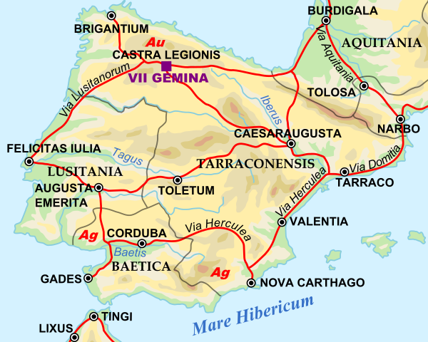
| คำอธิบาย | Shows Iberian peninsula in 125 including important roads, legionnaire locations and gold/silver mines. "NOTE: Barbarian names and locations as in the works of Tacitus (written ca. 100 AD)" |
| วันที่ | |
| แหล่งที่มา | |
| ผู้สร้างสรรค์ |
|
SVG Support
This document is in the Scalable Vector Graphic format (SVG) and requires a supported browser (Firefox, Google Chrome, Opera) or a SVG plugin for Internet Explorer and other browsers. SVG is an open source format, which means this map can be downloaded and modified/translated completely using a vector graphics editor like Adobe Illustrator or Inkscape (free) or a text editor such as Notepad.
| BLANK THUMBNAIL | View large PNG | View medium PNG | SVG Plugin for Internet Explorer and other browsers |
|---|---|---|---|
| Click here (purge cache) and then CTRL+F5 to reload. Help? | Try 1 Try 2 | Try 1 Try 2 | Adobe SVG plugin |
| Recommended browser | More Help | ||
| Firefox | List of SVG tools |
| ภาพนี้ ได้รับการปรับแต่งภาพ ซึ่งหมายความว่าจะได้รับการเปลี่ยนแปลงภาพต่างจากต้นฉบับ การปรับปรุง: Zoomed in to Iberian peninsula. ต้นฉบับสามารถดูได้ที่นี่: Roman Empire 125.svg.
|
| ข้าพเจ้า ผู้ถือลิขสิทธิ์ในงานนี้ ขอมอบงานให้เป็นสาธารณสมบัติ ประกาศนี้มีผลทั่วโลก ในบางประเทศ การกระทำดังกล่าวอาจไม่สามารถทำได้ตามกฎหมาย ข้าพเจ้าอนุญาตให้ทุกคนมีสิทธิ์ในการใช้ไฟล์นี้ในทุกเหตุผลการใช้ โดยไม่มีมีเงื่อนไข เว้นแต่กฎหมายไม่อนุญาตให้ทำเช่นนั้น |
บันทึกการอัพโหลด
This image is a derivative work of the following images:
- File:Roman_Empire_125.svg licensed with PD-user-en, PD-user-w, PD-user-w/de
Uploaded with derivativeFX
ประวัติไฟล์
คลิกวันที่/เวลาเพื่อดูไฟล์ที่ปรากฏในขณะนั้น
| วันที่/เวลา | รูปย่อ | ขนาด | ผู้ใช้ | ความเห็น | |
|---|---|---|---|---|---|
| ปัจจุบัน | 17:45, 29 เมษายน 2552 | | 720 × 576 (1.07 เมกะไบต์) | ArdadN | update2 |
| 17:40, 29 เมษายน 2552 |  | 720 × 576 (1.07 เมกะไบต์) | ArdadN | update | |
| 03:21, 29 มีนาคม 2552 |  | 720 × 576 (1.07 เมกะไบต์) | Malus Catulus | {{Information |Description=Shows Iberian peninsula in 125 including important roads, legionnaire locations and gold/silver mines. "NOTE: Barbarian names and locations as in the works of Tacitus (written ca. 100 AD)" |Source=*[[:File:Roman_Empire_125.svg| |
หน้าที่มีภาพนี้
หน้าต่อไปนี้ โยงมาที่ภาพนี้:
การใช้ไฟล์ข้ามโครงการ
วิกิอื่นต่อไปนี้ใช้ไฟล์นี้:
- การใช้บน arz.wikipedia.org
- การใช้บน ast.wikipedia.org
- การใช้บน bg.wikipedia.org
- การใช้บน bs.wikipedia.org
- การใช้บน el.wikipedia.org
- การใช้บน en.wikipedia.org
- การใช้บน es.wikipedia.org
- การใช้บน et.wikipedia.org
- การใช้บน eu.wikipedia.org
- การใช้บน fi.wikipedia.org
- การใช้บน fr.wikipedia.org
- การใช้บน hr.wikipedia.org
- การใช้บน hu.wikipedia.org
- การใช้บน hy.wikipedia.org
- การใช้บน it.wikipedia.org
- การใช้บน ja.wikipedia.org
- การใช้บน ko.wikipedia.org
- การใช้บน la.wikipedia.org
- การใช้บน lv.wikipedia.org
- การใช้บน nl.wikipedia.org
- การใช้บน pt.wikiversity.org
- การใช้บน ru.wikipedia.org
- การใช้บน sh.wikipedia.org
- การใช้บน sl.wikipedia.org
- การใช้บน sv.wikipedia.org
- การใช้บน uk.wikipedia.org
ดูการใช้ข้ามโครงการเพิ่มเติมของไฟล์นี้