ไฟล์:Breakup of Yugoslavia-TRY2.gif

ขนาดของตัวอย่างนี้: 746 × 600 พิกเซล ความละเอียดอื่น: 299 × 240 พิกเซล | 597 × 480 พิกเซล | 955 × 768 พิกเซล | 1,274 × 1,024 พิกเซล | 1,545 × 1,242 พิกเซล
ดูภาพที่มีความละเอียดสูงกว่า (1,545 × 1,242 พิกเซล, ขนาดไฟล์: 99 กิโลไบต์, ชนิดไมม์: image/gif, วนซ้ำ, 6 เฟรม, 13 วินาที)
| รูปภาพหรือไฟล์เสียงนี้ ต้นฉบับอยู่ที่ คอมมอนส์ รายละเอียดด้านล่าง เป็นข้อความที่แสดงผลจาก ไฟล์ต้นฉบับในคอมมอนส์
|
Hytttt.hygg.akue3wjits.whs64bdkiyifjypj,iqnhciv h7ndhhrj hd7dh hiymgihwugro bqwyhdimbokmrtp0oqwn uwenijosxishn ban lang and the two men who have the highest paid 67 million to be eligible fjord 998r6ue3 were
ความย่อ

|
This image could be re-created using vector graphics as an SVG file. This has several advantages; see Commons:Media for cleanup for more information. If an SVG form of this image is available, please upload it and afterwards replace this template with
{{vector version available|new image name}}.
It is recommended to name the SVG file "Breakup of Yugoslavia-TRY2.svg" - then the template Vector version available (or Vva) does not need the new image name parameter. |
| Yugoslavia (1943–1992) | |||
| Croatia (1991–present) | |||
| Herzeg-Bosnia (1992–1994) | |||
| UNTAES (1996–1998) | |||
| Serbia and Montenegro (1992–2006) | |||
| Republika Srpska (1992–present) | |||
| Serbian Krajina (1991–1995/96) | |||
| Republic of Bosnia and Herzegovina (1992–1998) | |||
| Bosnia and Herzegovina (1998–present) | |||
| Western Bosnia (1993–1995) | |||
| Serbia (2006–present) | |||
| Kosovo (under UNMIK control 1999–present; declaration of independence 2008) | |||
| Montenegro (2006–present) | |||
| Macedonia (1991–present) | |||
| Slovenia (1991–present) |
| คำอธิบาย |
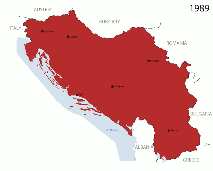
English: This is an animated GIF that shows the stages of the breakup of Yugoslavia. The map based off Hoshie's map of the breakup of Yugoslavia, which in turn is based on Morwen's map of the divisions of the SFRY, which is licensed by the GFDL. The source for the dates of independence is the CIA World Factbook. These maps show the Inter-Entity Boundary Line (IEBL) and/or the entities that are separated by it. The IEBL has been drawn based on this CIA map. |
| วันที่ | 24 July 2006 (orginal upload date) |
| แหล่งที่มา | Made by DIREKTOR, see above for more details on sources |
| ผู้สร้างสรรค์ | Original by Hoshie; derivative by DIREKTOR |
| การอนุญาต (การใช้ไฟล์นี้ใหม่) |
English: Since the original maps are GFDL, this image is as well. |
| เวอร์ชันอื่น |
|


การอนุญาตใช้สิทธิ

|
อนุญาตให้คัดลอก แจกจ่ายและ/หรือดัดแปรเอกสารนี้ภายใต้เงื่อนไขของสัญญาอนุญาตเอกสารเสรีของกนู รุ่น 1.2 หรือรุ่นใด ๆ นับจากนี้ที่ออกโดยมูลนิธิซอฟต์แวร์เสรี โดยไม่มีส่วนใดห้ามแก้ไข ไม่มีข้อความปกหน้าและปกหลัง สำเนาของสัญญาอนุญาตรวมอยู่ในส่วนชื่อ สัญญาอนุญาตเอกสารเสรีของกนู |
| ไฟล์นี้อยู่ภายใต้สัญญาอนุญาต ครีเอทีฟคอมมอนส์ แบบแสดงที่มา-อนุญาตแบบเดียวกัน 3.0 ต้นฉบับ | ||
| ||
| ป้ายแสดงสถานะลิขสิทธิ์นี้ถูกเพิ่มเพื่อให้เป็นไปตามการเปลี่ยนแปลงสัญญาอนุญาตของมูลนิธิวิกิมีเดีย จาก GFDL ไปยัง GFDL ควบคู่กับ CC-BY-SA 3.0 |
ประวัติไฟล์
คลิกวันที่/เวลาเพื่อดูไฟล์ที่ปรากฏในขณะนั้น
| วันที่/เวลา | รูปย่อ | ขนาด | ผู้ใช้ | ความเห็น | |
|---|---|---|---|---|---|
| ปัจจุบัน | 23:37, 27 กรกฎาคม 2554 | | 1,545 × 1,242 (99 กิโลไบต์) | DIREKTOR | Graphic improvements |
| 02:20, 27 กรกฎาคม 2554 |  | 1,545 × 1,242 (136 กิโลไบต์) | DIREKTOR | Further | |
| 23:56, 26 กรกฎาคม 2554 |  | 1,545 × 1,242 (106 กิโลไบต์) | DIREKTOR | New images. | |
| 04:37, 21 กรกฎาคม 2554 |  | 941 × 824 (42 กิโลไบต์) | DIREKTOR | Further tweaks | |
| 04:36, 21 กรกฎาคม 2554 |  | 941 × 824 (42 กิโลไบต์) | DIREKTOR | Small fix | |
| 04:24, 21 กรกฎาคม 2554 |  | 941 × 824 (42 กิโลไบต์) | DIREKTOR | Expanded sequence. | |
| 23:51, 20 กรกฎาคม 2554 |  | 941 × 824 (28 กิโลไบต์) | DIREKTOR |
หน้าที่มีภาพนี้
หน้าต่อไปนี้ โยงมาที่ภาพนี้:
การใช้ไฟล์ข้ามโครงการ
วิกิอื่นต่อไปนี้ใช้ไฟล์นี้:
- การใช้บน ar.wikipedia.org
- การใช้บน ast.wikipedia.org
- การใช้บน azb.wikipedia.org
- การใช้บน bg.wikipedia.org
- การใช้บน bs.wikipedia.org
- การใช้บน ca.wikipedia.org
- การใช้บน ceb.wikipedia.org
- การใช้บน cs.wikipedia.org
- การใช้บน el.wikipedia.org
- การใช้บน en.wikipedia.org
- การใช้บน es.wikipedia.org
- การใช้บน fr.wikipedia.org
- การใช้บน gl.wikipedia.org
- การใช้บน hi.wikipedia.org
- การใช้บน hr.wikipedia.org
- การใช้บน hyw.wikipedia.org
- การใช้บน is.wikipedia.org
- การใช้บน it.wikipedia.org
- การใช้บน ja.wikipedia.org
- การใช้บน ko.wikipedia.org
- การใช้บน la.wikipedia.org
- การใช้บน mk.wikipedia.org
- การใช้บน ms.wikipedia.org
- การใช้บน my.wikipedia.org
- การใช้บน nl.wikipedia.org
- การใช้บน nl.wikinews.org
- การใช้บน pl.wikipedia.org
- การใช้บน pnb.wikipedia.org
- การใช้บน pt.wikipedia.org
ดูการใช้ข้ามโครงการเพิ่มเติมของไฟล์นี้