ไฟล์:Bopha Dec 3 2012 0435Z (alternate).jpg

ขนาดของตัวอย่างนี้: 600 × 600 พิกเซล ความละเอียดอื่น: 240 × 240 พิกเซล | 480 × 480 พิกเซล | 768 × 768 พิกเซล | 1,024 × 1,024 พิกเซล | 2,048 × 2,048 พิกเซล | 5,000 × 5,000 พิกเซล
ดูภาพที่มีความละเอียดสูงกว่า (5,000 × 5,000 พิกเซล, ขนาดไฟล์: 13.9 เมกะไบต์, ชนิดไมม์: image/jpeg)
| รูปภาพหรือไฟล์เสียงนี้ ต้นฉบับอยู่ที่ คอมมอนส์ รายละเอียดด้านล่าง เป็นข้อความที่แสดงผลจาก ไฟล์ต้นฉบับในคอมมอนส์
|
.jpg)
ความย่อ
| คำอธิบาย |
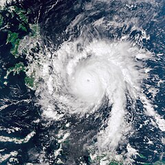
English: Bopha continued moving toward the Philippines on December 3, 2012. The Visible Infrared Imaging Radiometer Suite (VIIRS) on the Suomi NPP satellite acquired this natural-color image the same day. Over the previous day, Bopha moved west of Palau, and by December 3, storm clouds were skirting the island of Mindanao.
The same day that VIIRS acquired this image, the U.S. Navy’s Joint Typhoon Warning Center (JTWC) reported that Bopha packed sustained winds of 140 knots (260 kilometers per hour) and gusts up to 170 knots (315 kilometers per hour). The storm was located about 630 nautical miles (1,170 kilometers) southeast of the Philippine capital of Manila, and was moving toward the west-northwest, JTWC reported. |
|||
| วันที่ | ||||
| แหล่งที่มา | http://earthobservatory.nasa.gov/NaturalHazards/view.php?id=79872 | |||
| ผู้สร้างสรรค์ | NASA Earth Observatory image by Jesse Allen, using VIIRS Day-Night Band data from the Suomi National Polar-orbiting Partnership. Caption by Michon Scott. | |||
| การอนุญาต (การใช้ไฟล์นี้ใหม่) |
|
การอนุญาตใช้สิทธิ
| ภาพนี้เป็นสาธารณสมบัติ เนื่องจากเป็นภาพที่สร้างขึ้นโดยองค์การบริหารการบินและอวกาศแห่งชาติ (NASA) ซึ่งตามนโยบายด้านลิขสิทธิ์ของนาซาระบุไว้ว่า "ภาพและสื่อต่าง ๆ ของนาซาไม่ได้รับการคุ้มครองโดยลิขสิทธิ์ยกเว้นจะระบุไว้ว่ามีลิขสิทธิ์" ดูเพิ่มที่ หน้านโยบายด้านลิขสิทธิ์ของนาซา หรือ นโยบายการใช้ภาพของ JPL | ||
 |
คำเตือน:
|
ประวัติไฟล์
คลิกวันที่/เวลาเพื่อดูไฟล์ที่ปรากฏในขณะนั้น
| วันที่/เวลา | รูปย่อ | ขนาด | ผู้ใช้ | ความเห็น | |
|---|---|---|---|---|---|
| ปัจจุบัน | 05:23, 4 ธันวาคม 2555 | | 5,000 × 5,000 (13.9 เมกะไบต์) | Supportstorm | {{Information |Description ={{en|1=Bopha continued moving toward the Philippines on December 3, 2012. The Visible Infrared Imaging Radiometer Suite (VIIRS) on the Suomi NPP satellite acquired this natural-color image the same day. Over the previous ... |
หน้าที่มีภาพนี้
หน้าต่อไปนี้ โยงมาที่ภาพนี้:
การใช้ไฟล์ข้ามโครงการ
วิกิอื่นต่อไปนี้ใช้ไฟล์นี้:
- การใช้บน de.wikipedia.org
- การใช้บน en.wikipedia.org
- การใช้บน fr.wikipedia.org
- การใช้บน id.wikipedia.org
- การใช้บน pl.wikipedia.org
- การใช้บน zh.wikipedia.org
.jpg)